Featured

Here is a more detailed both CONUS and for Michigan, October Climate Summary.

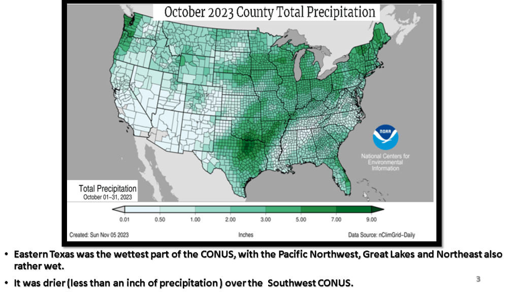
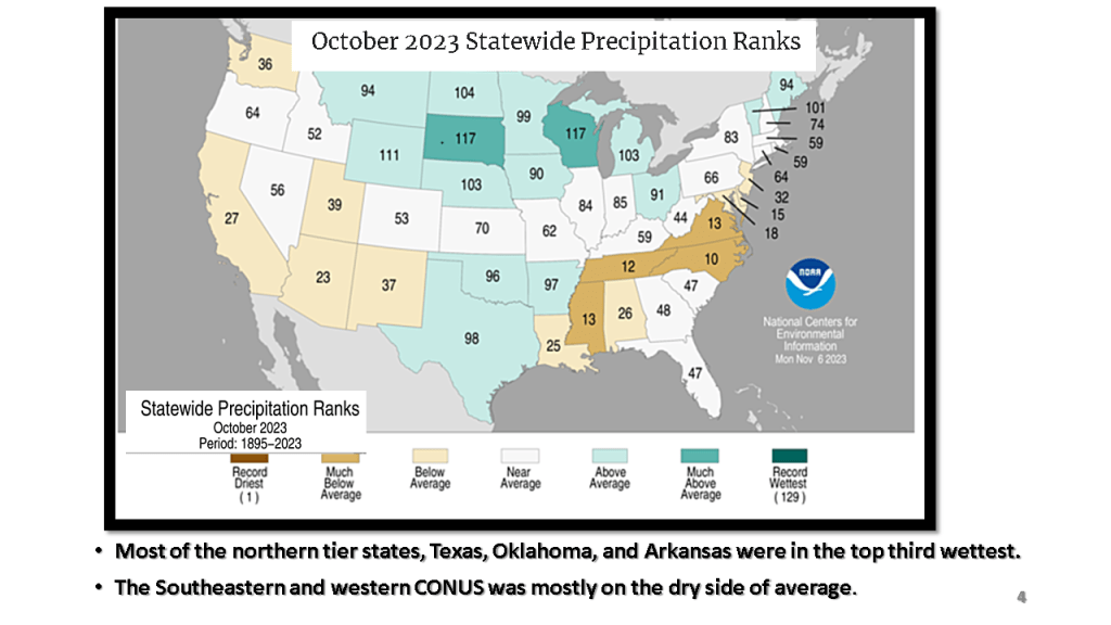
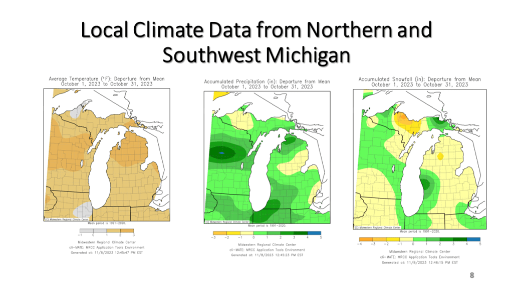
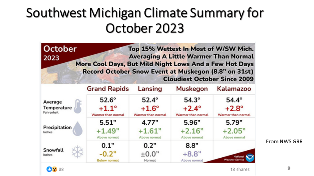
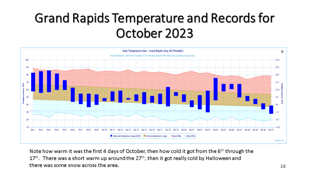
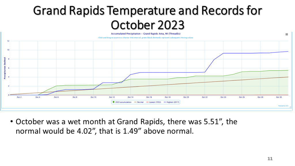
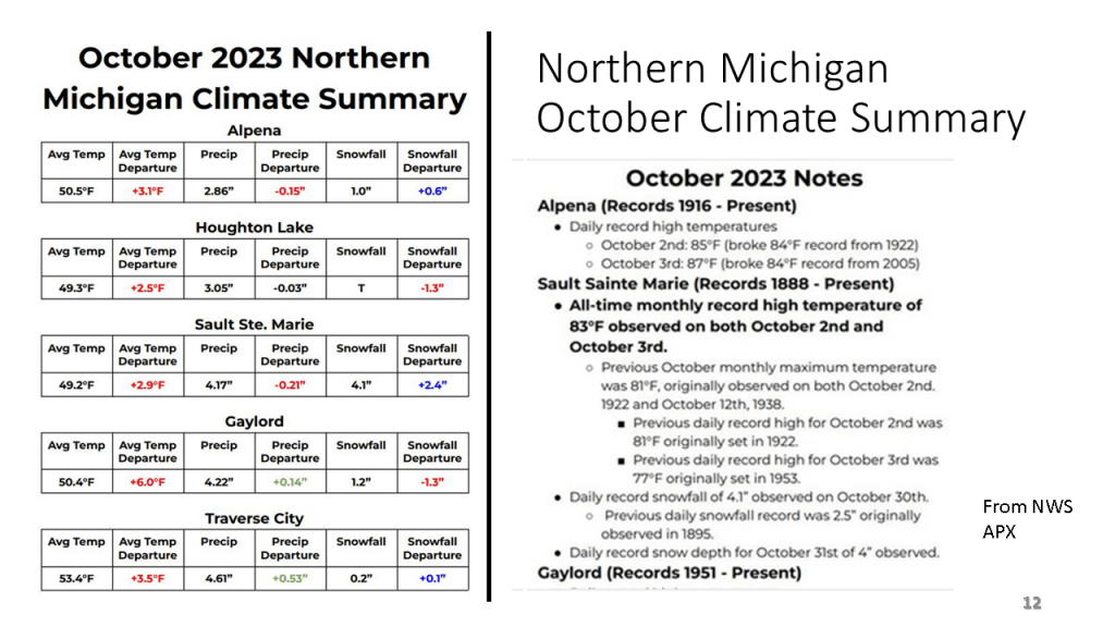
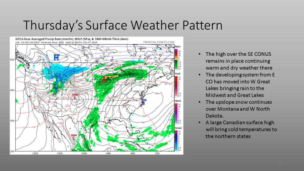
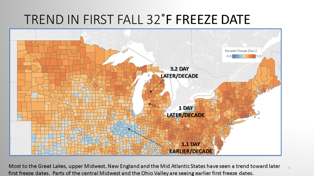
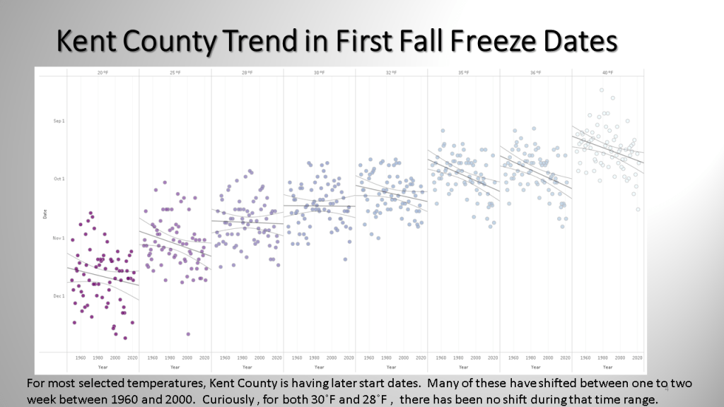
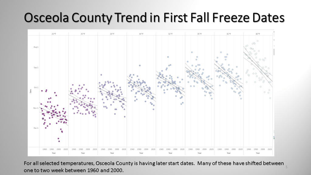
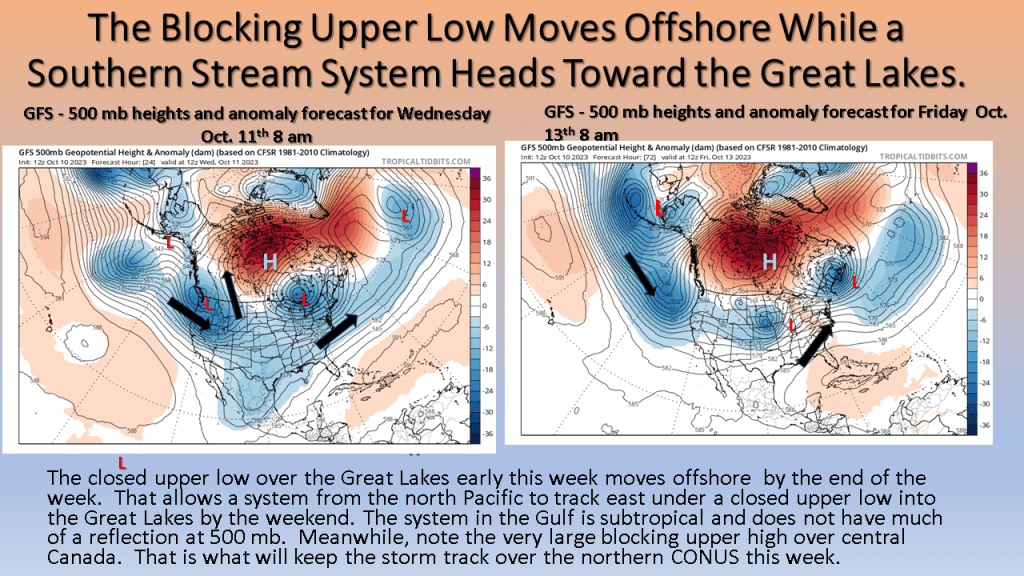
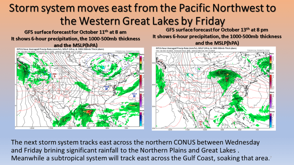
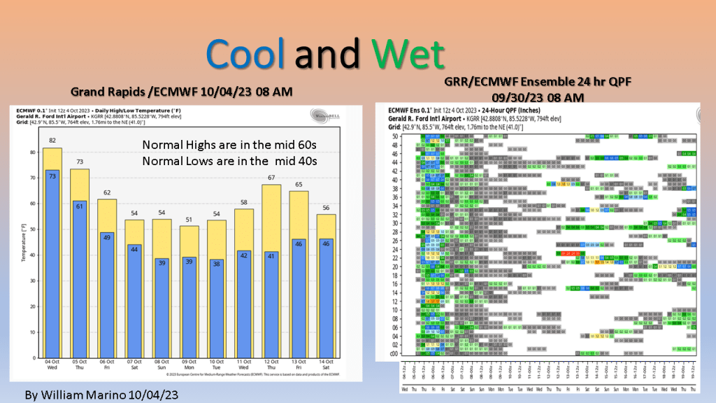
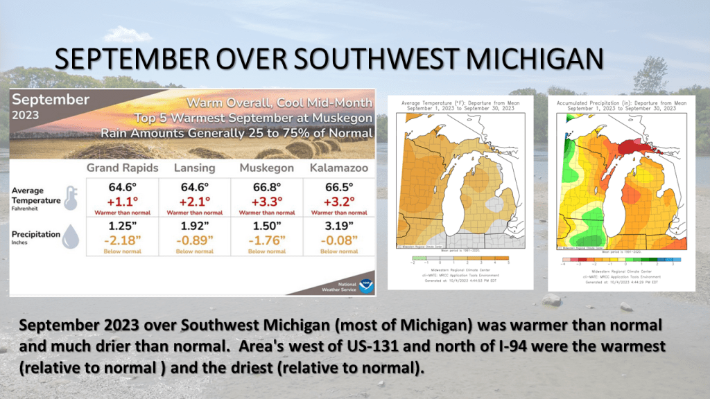
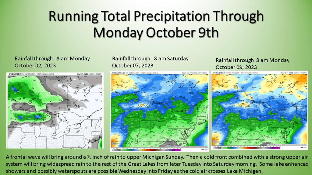
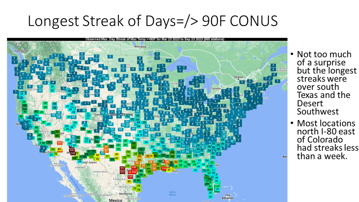
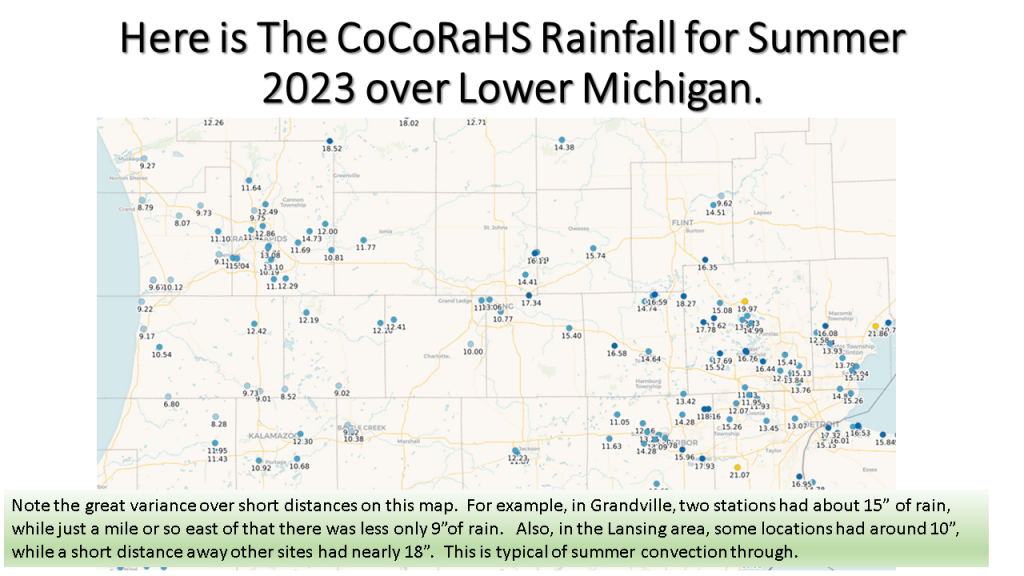
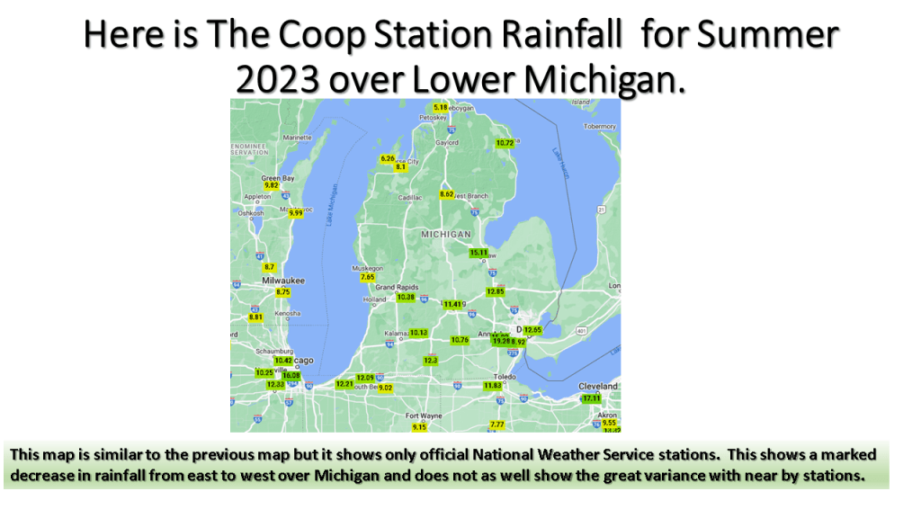
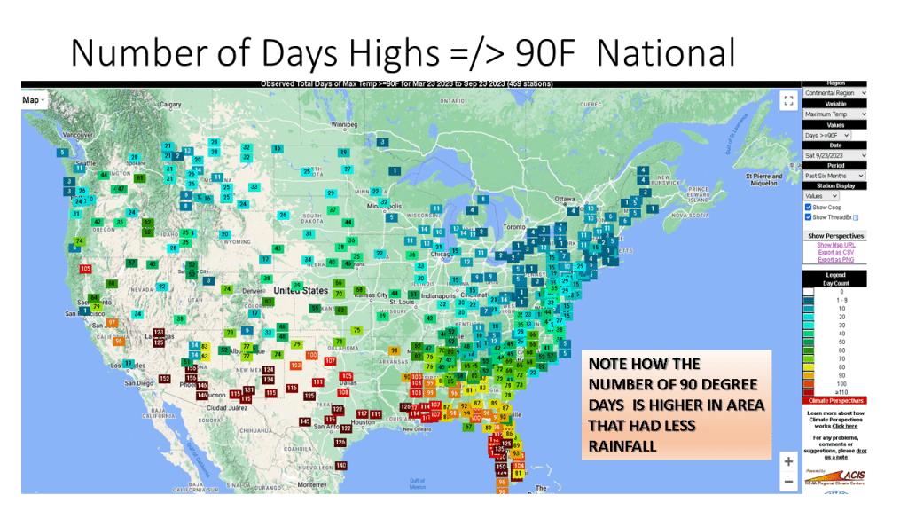
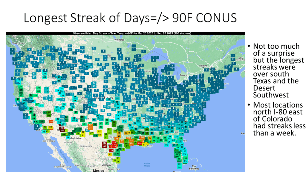
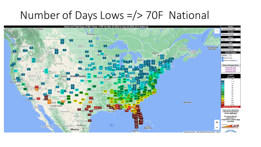
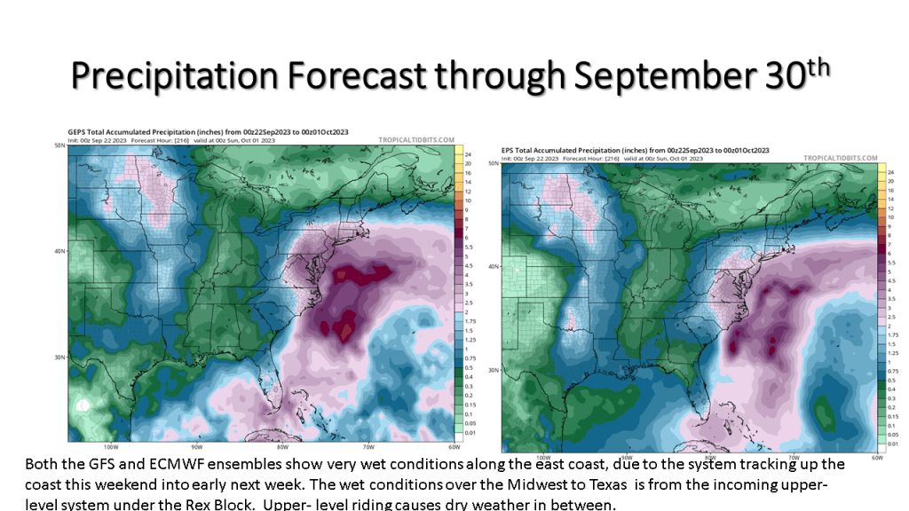
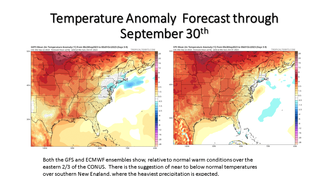
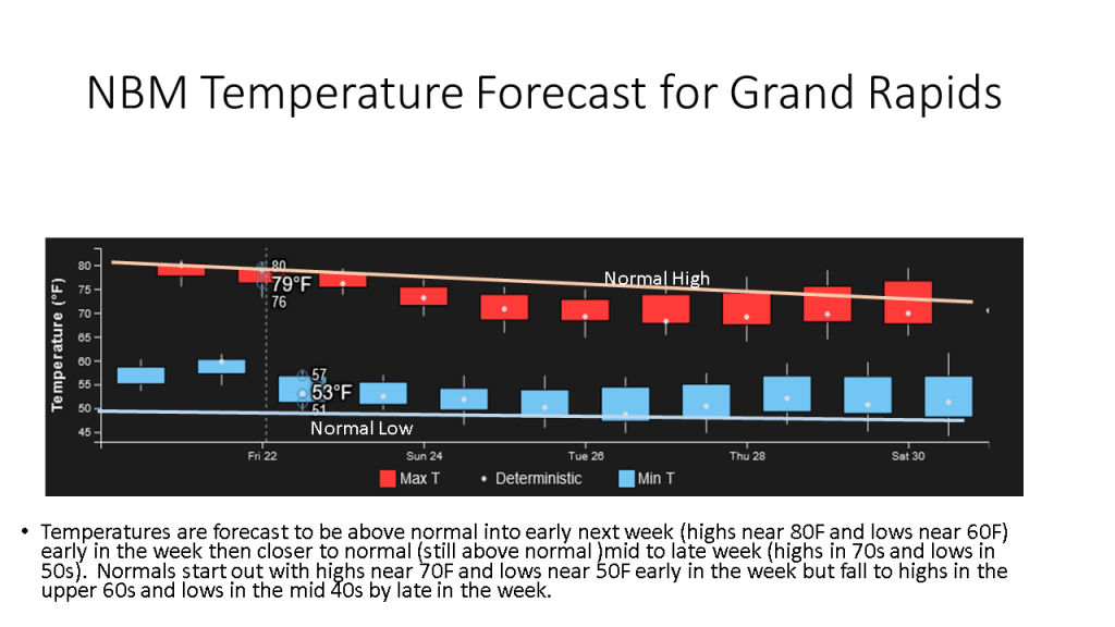
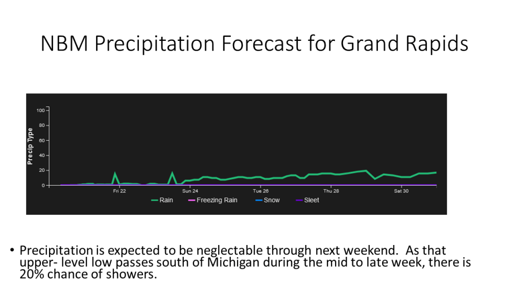
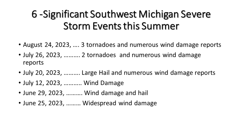
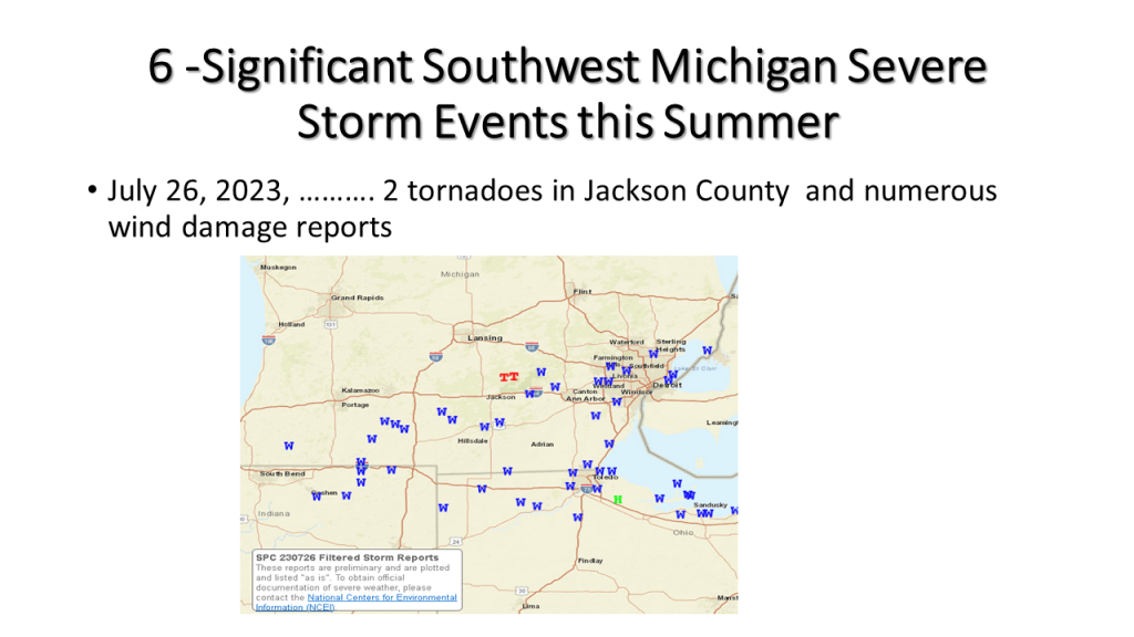
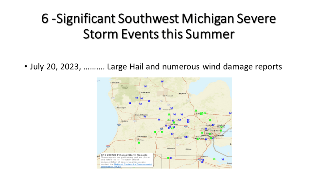
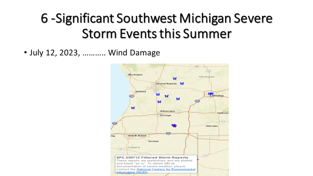
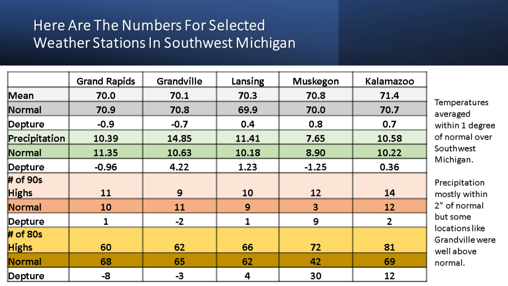
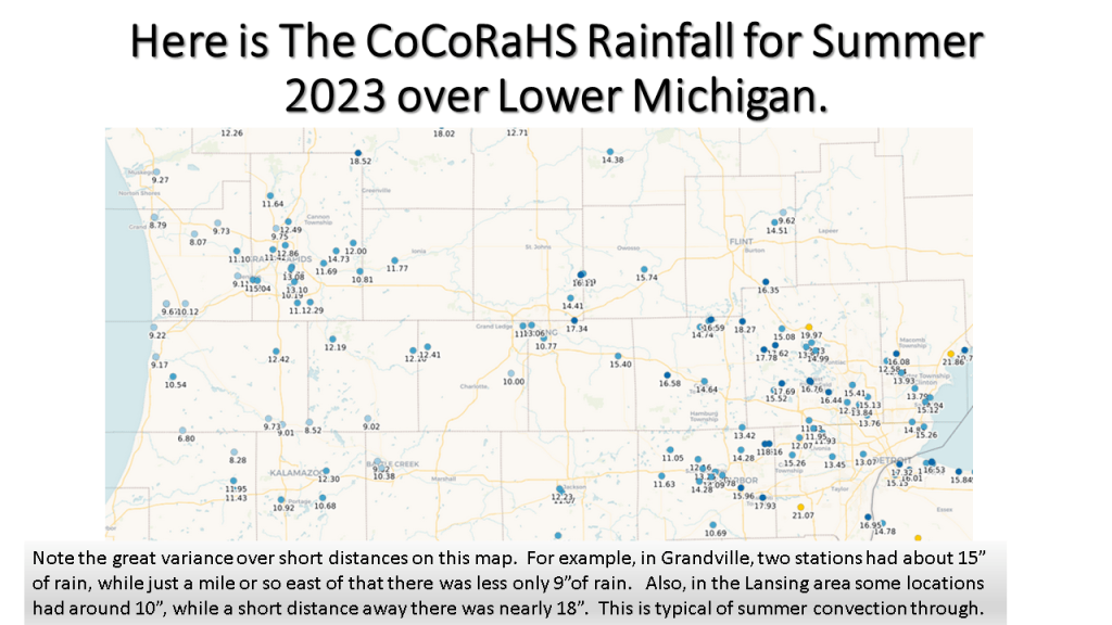
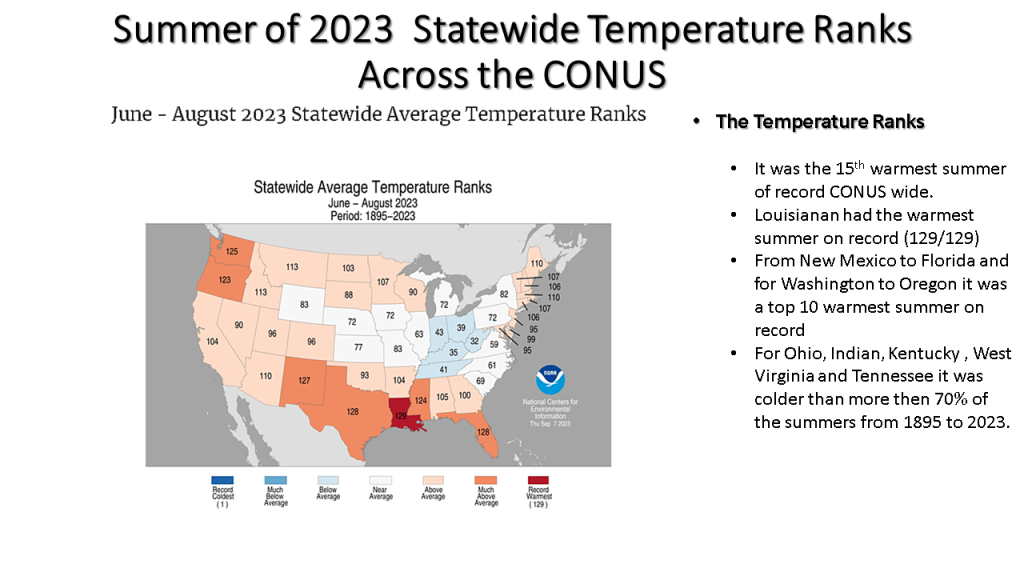
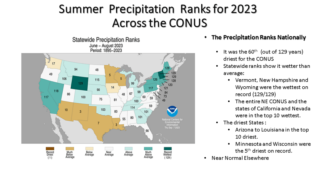
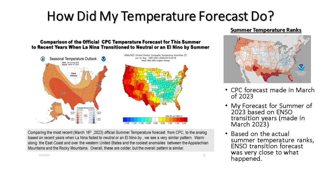
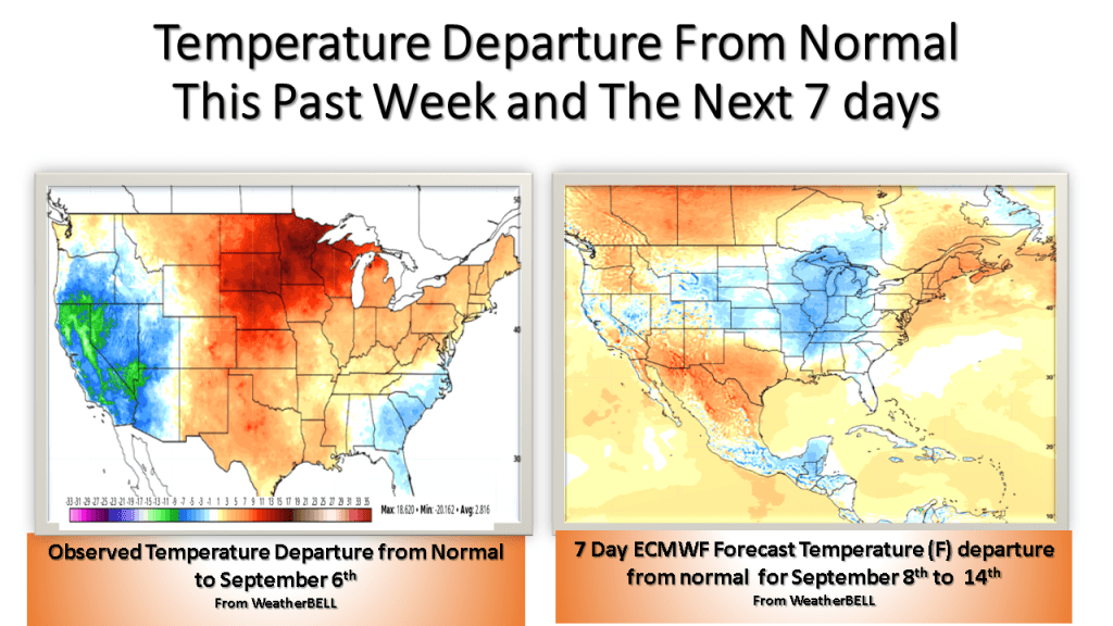
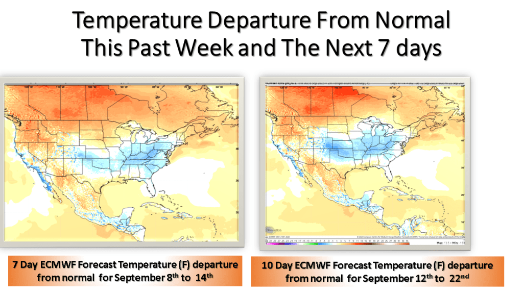
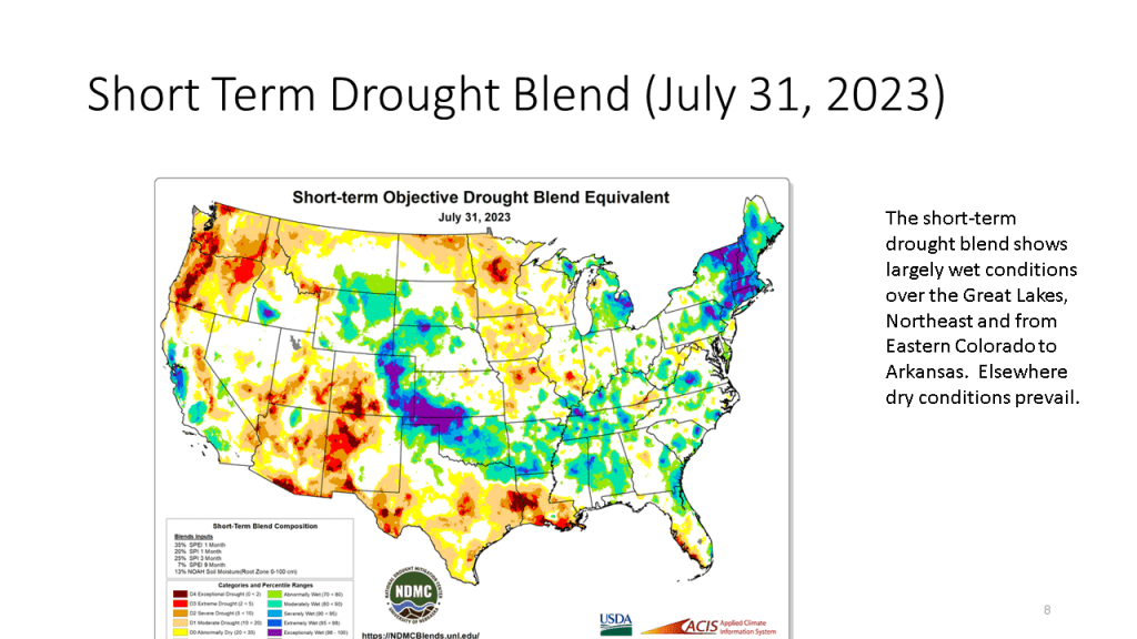
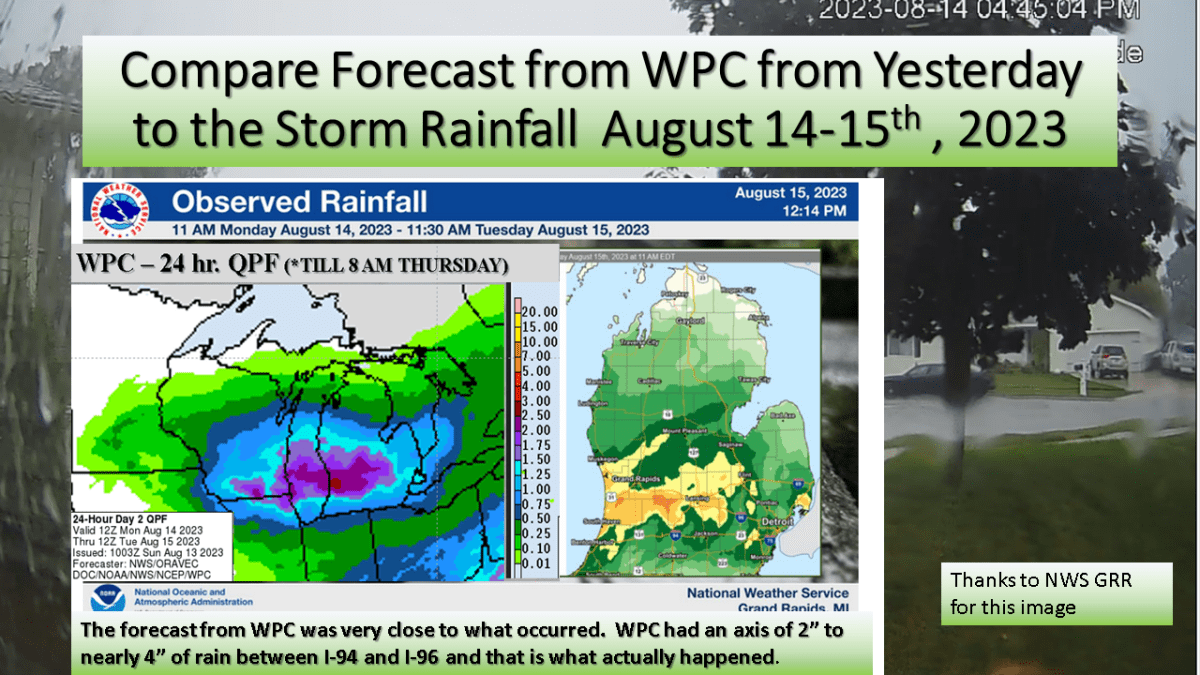
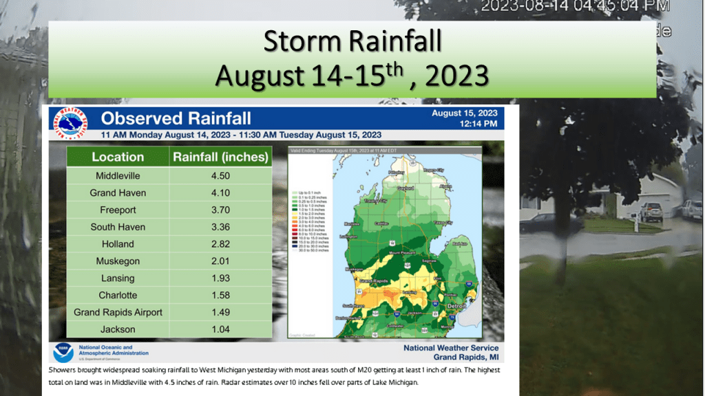
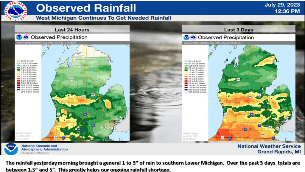
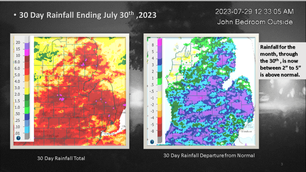
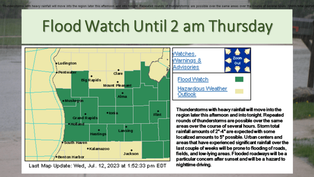
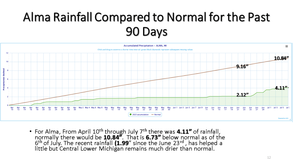
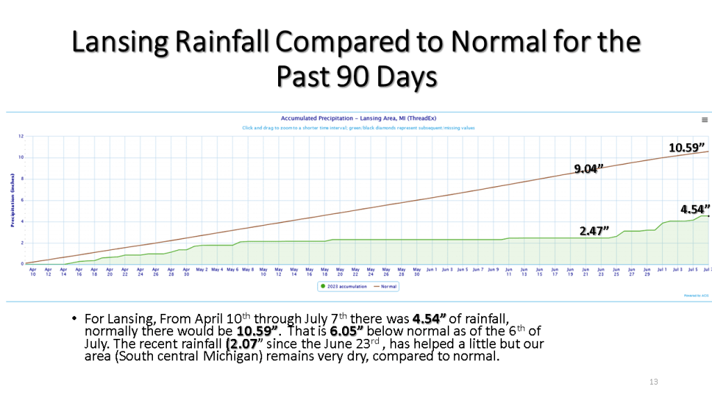
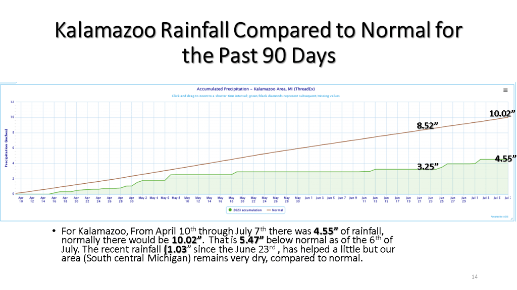
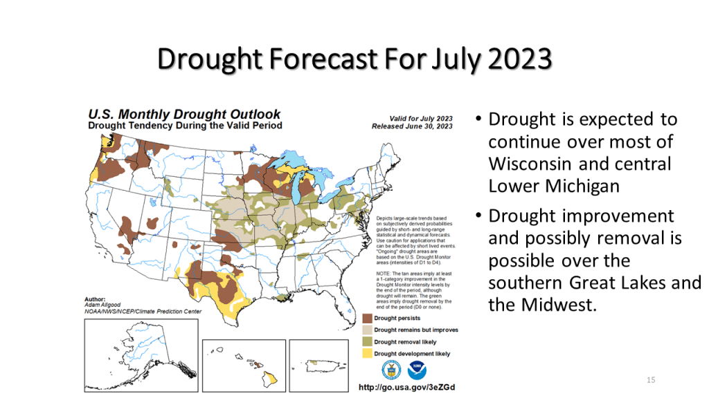
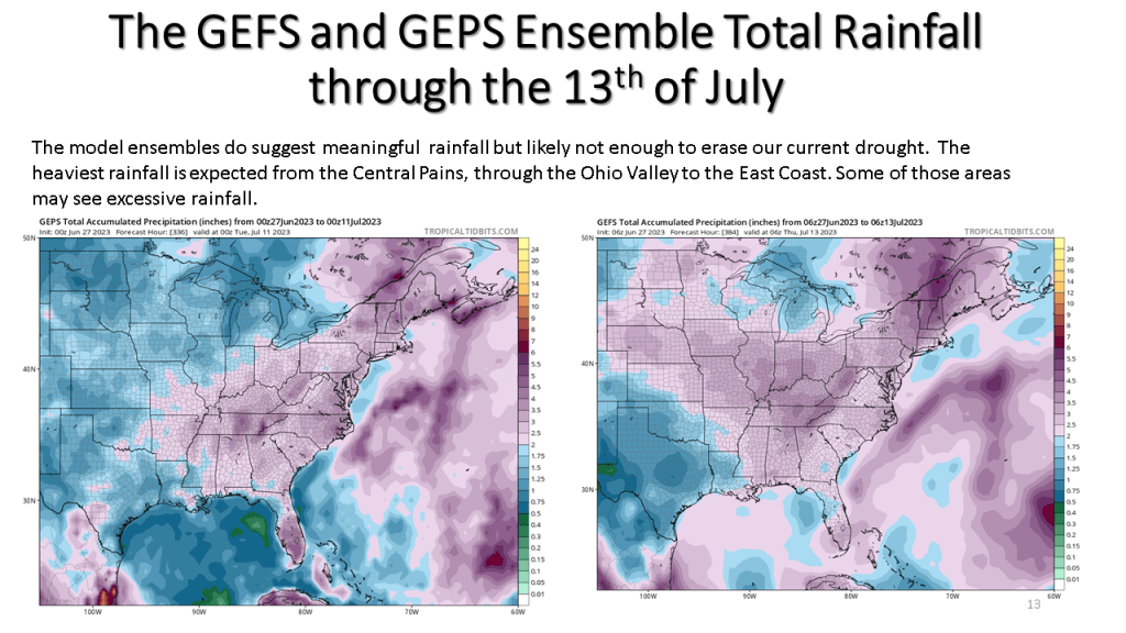
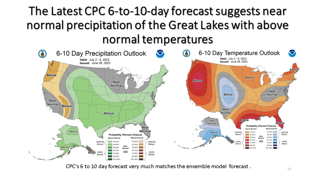
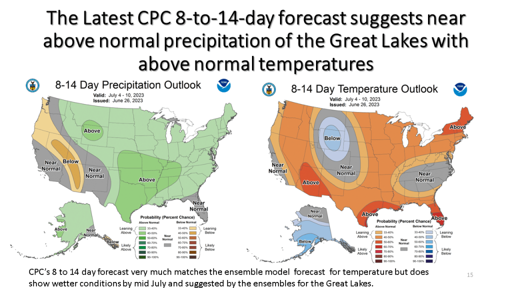
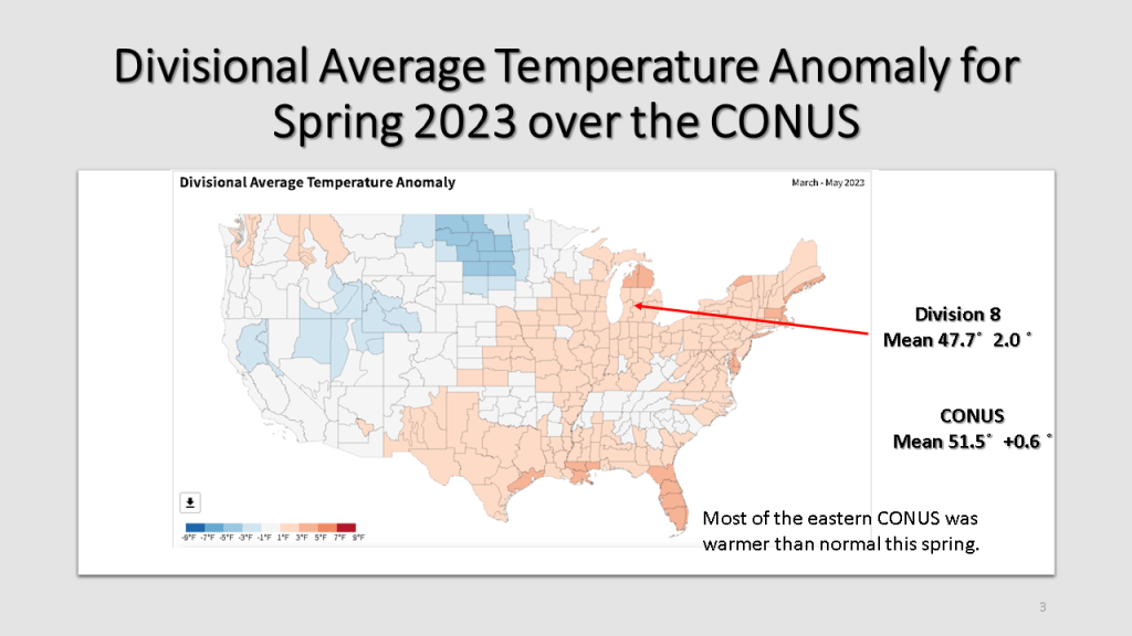
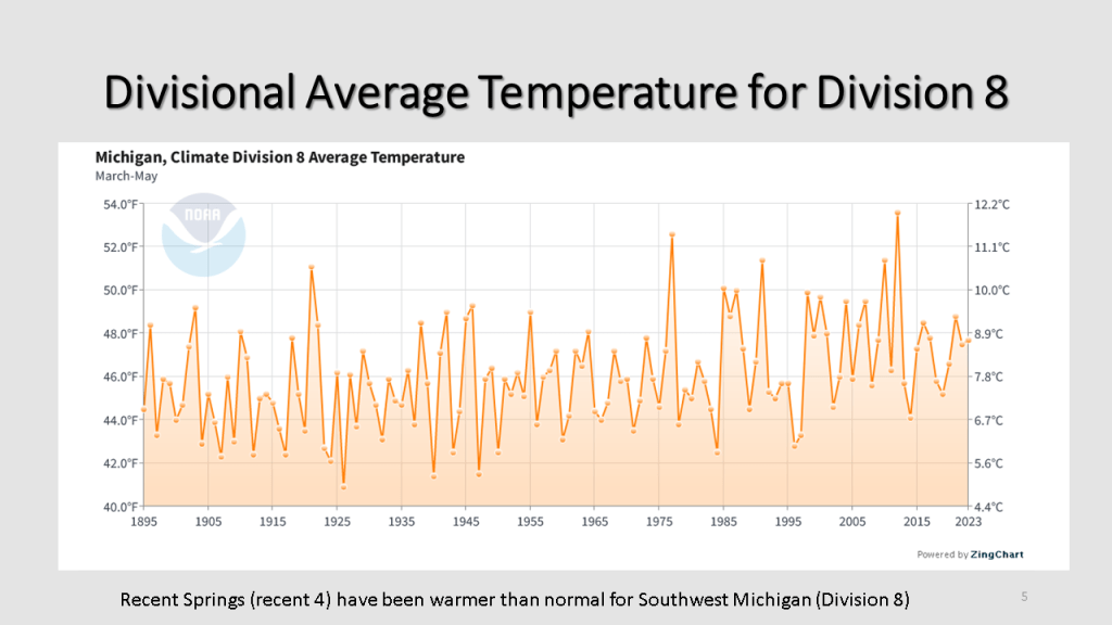
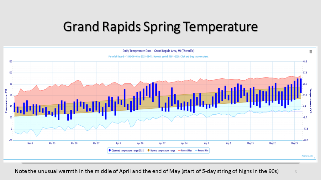
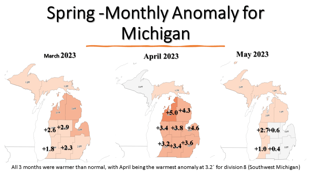
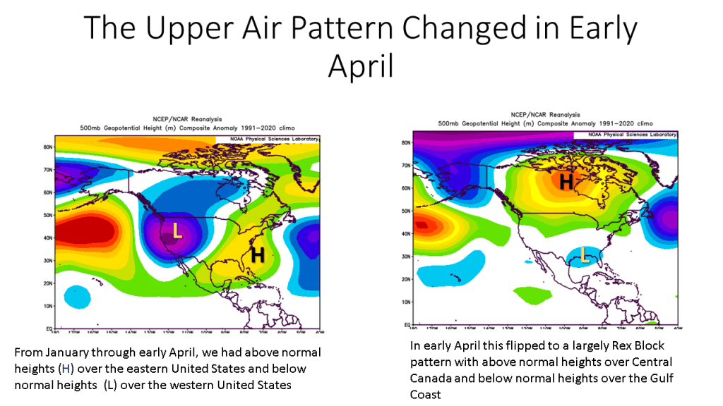
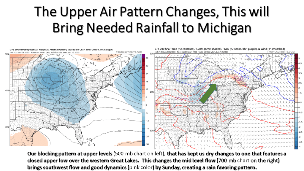
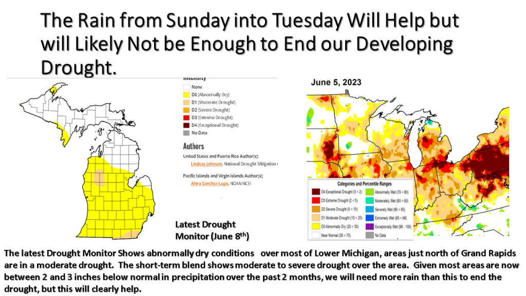
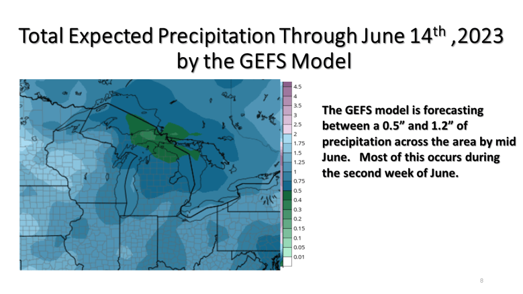
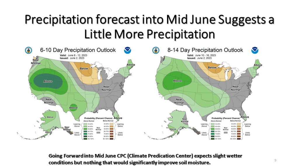
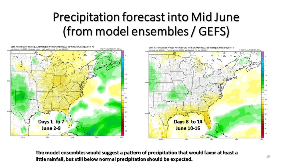
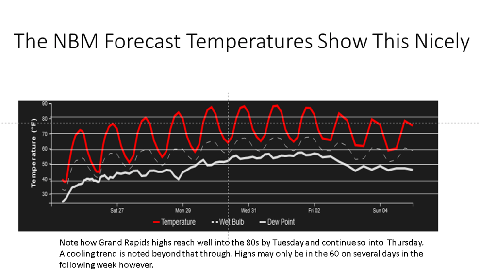
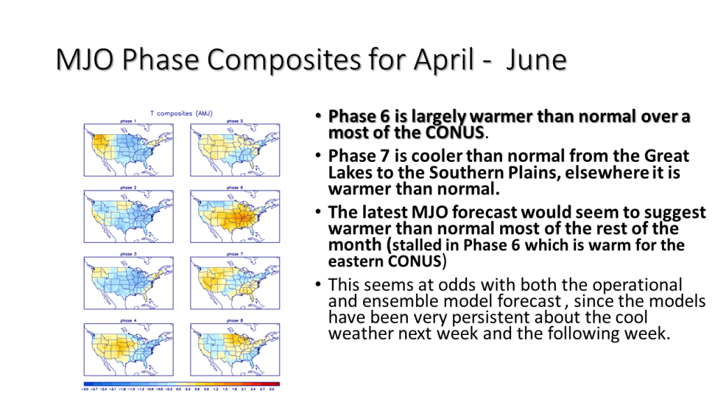
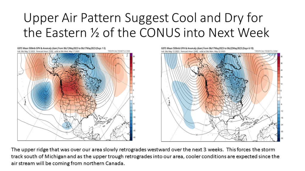
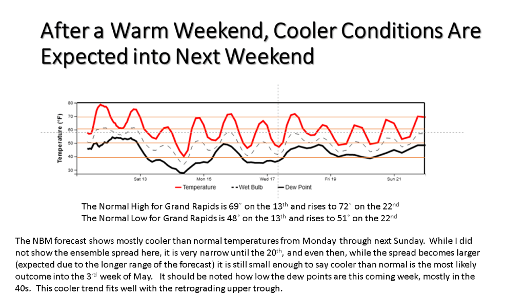
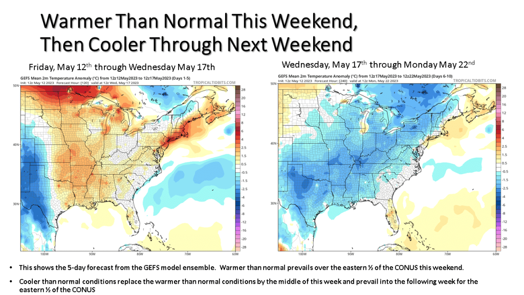
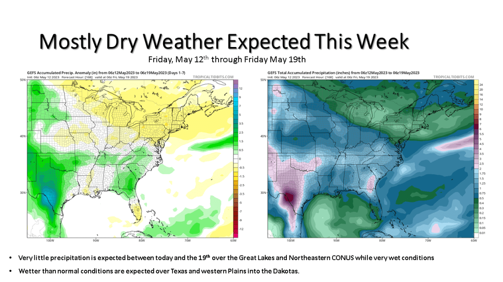
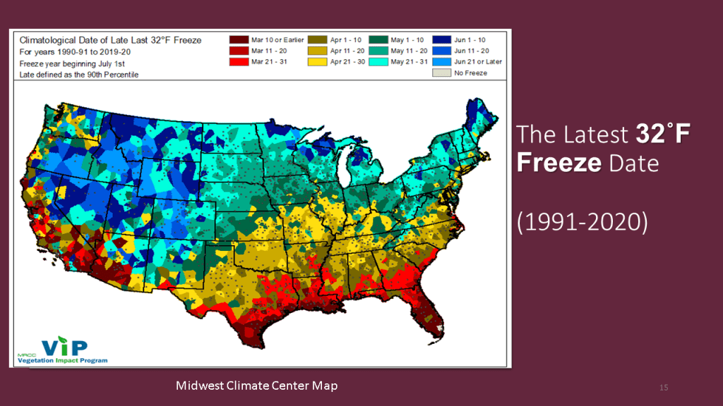
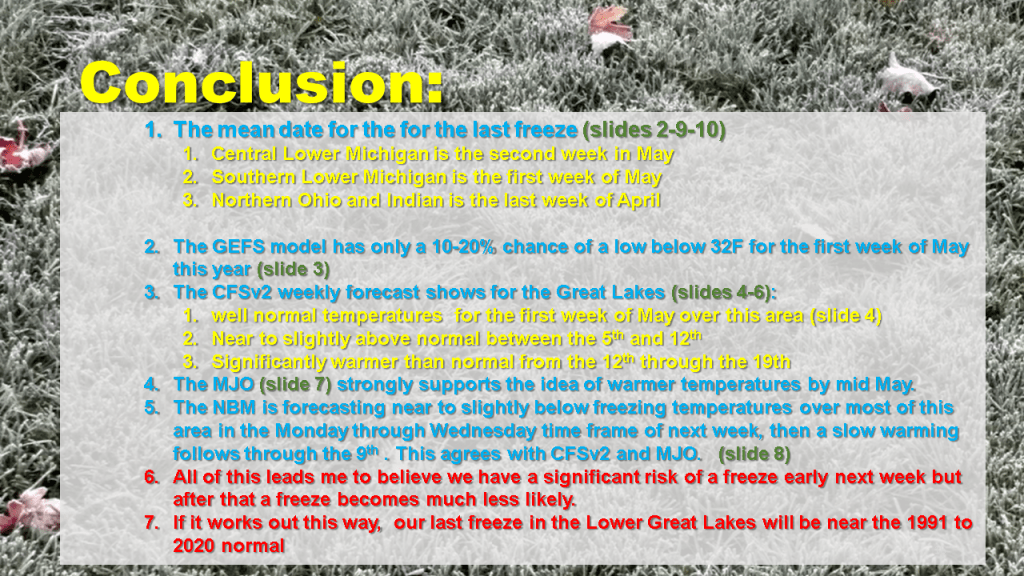
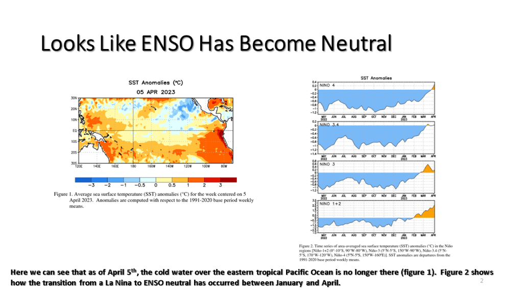
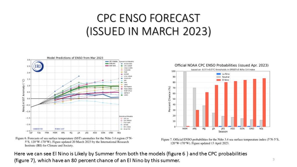
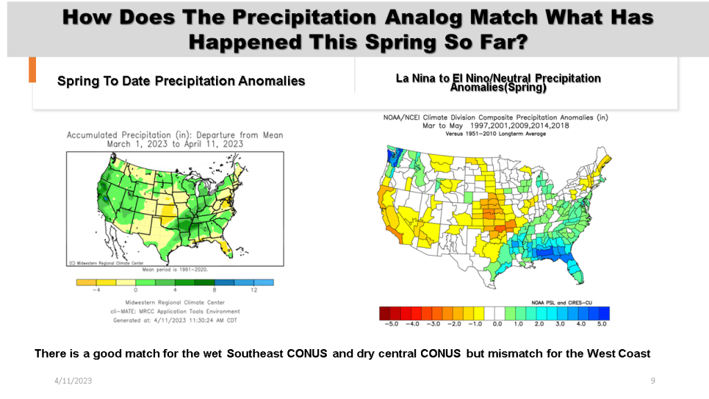
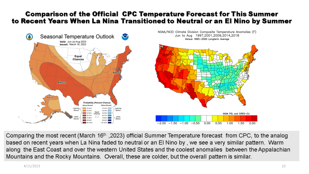
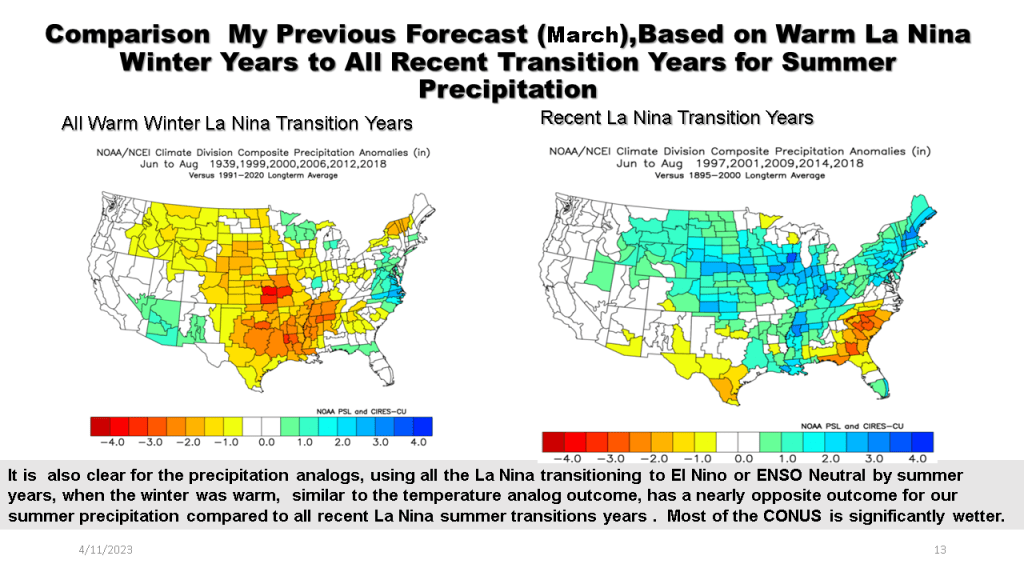
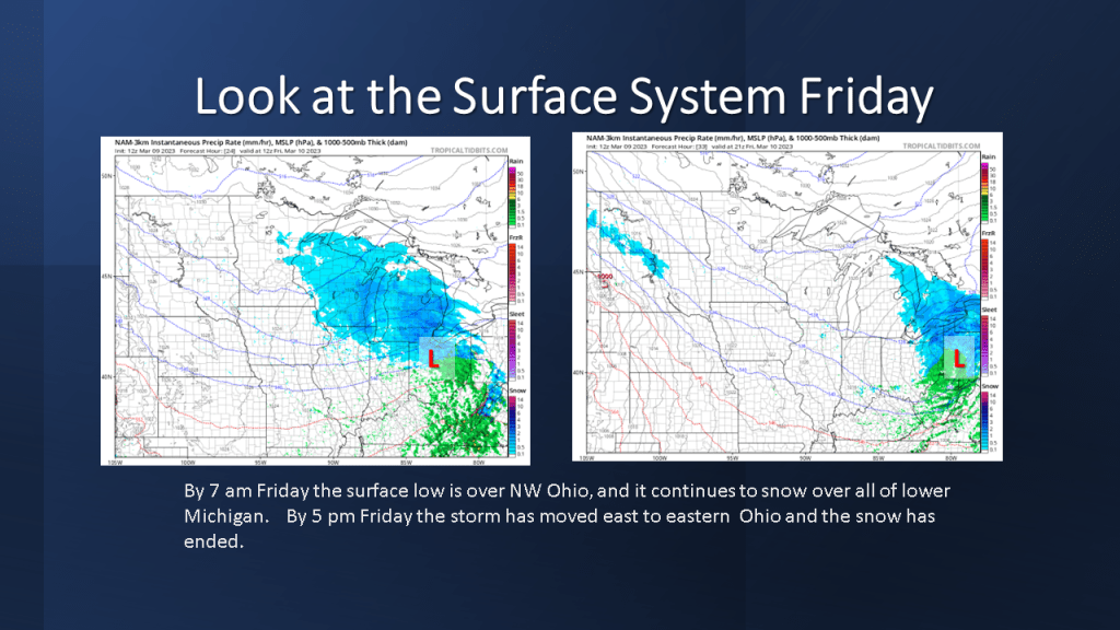
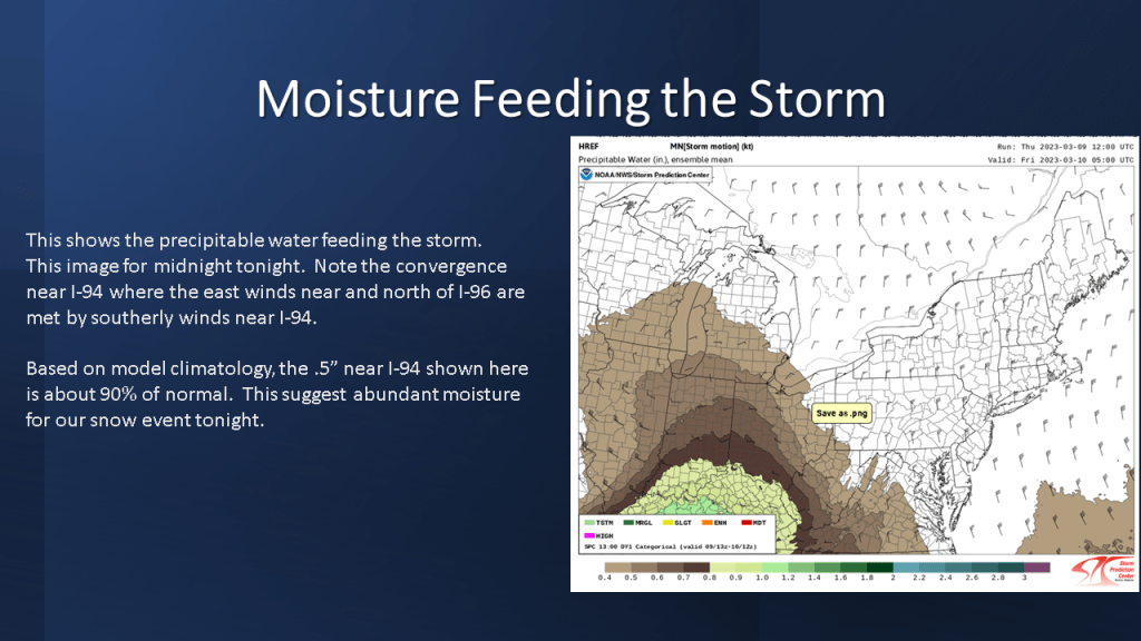
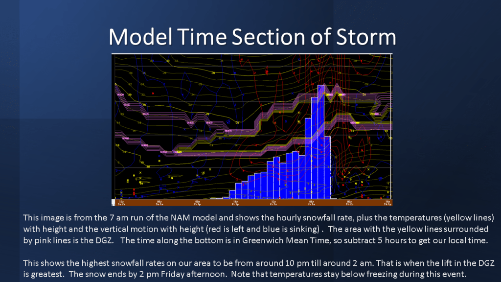
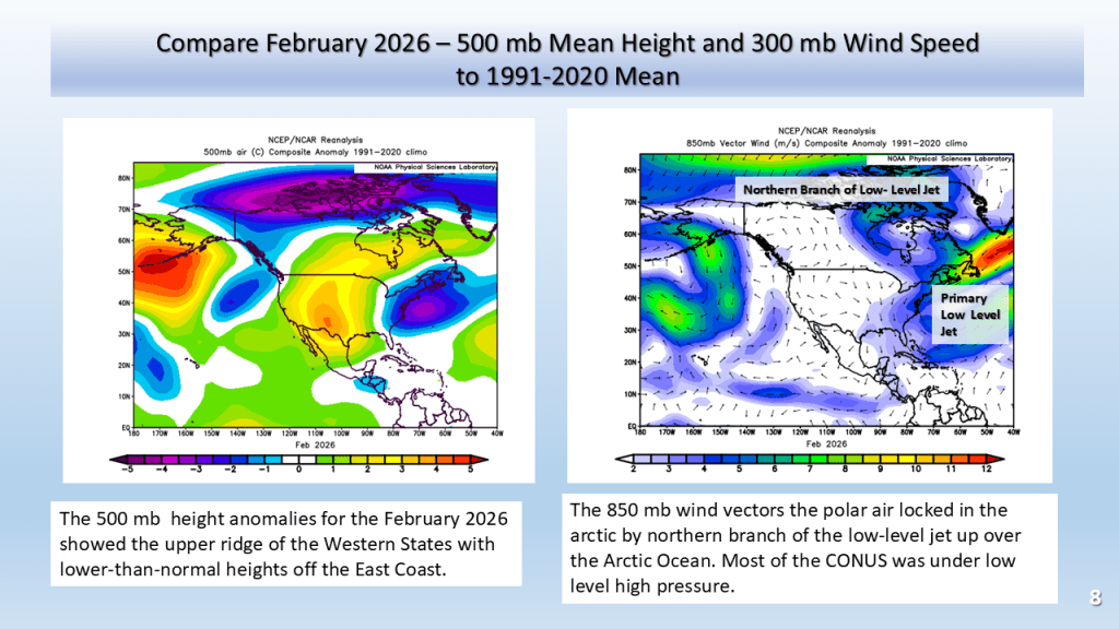
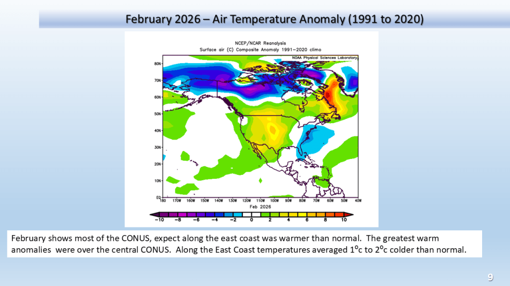
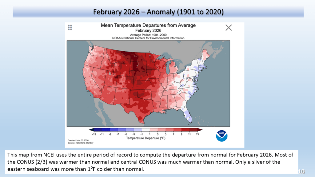
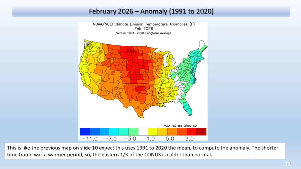
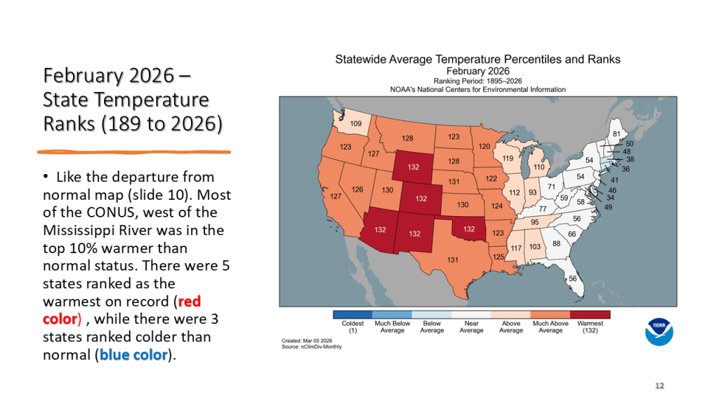
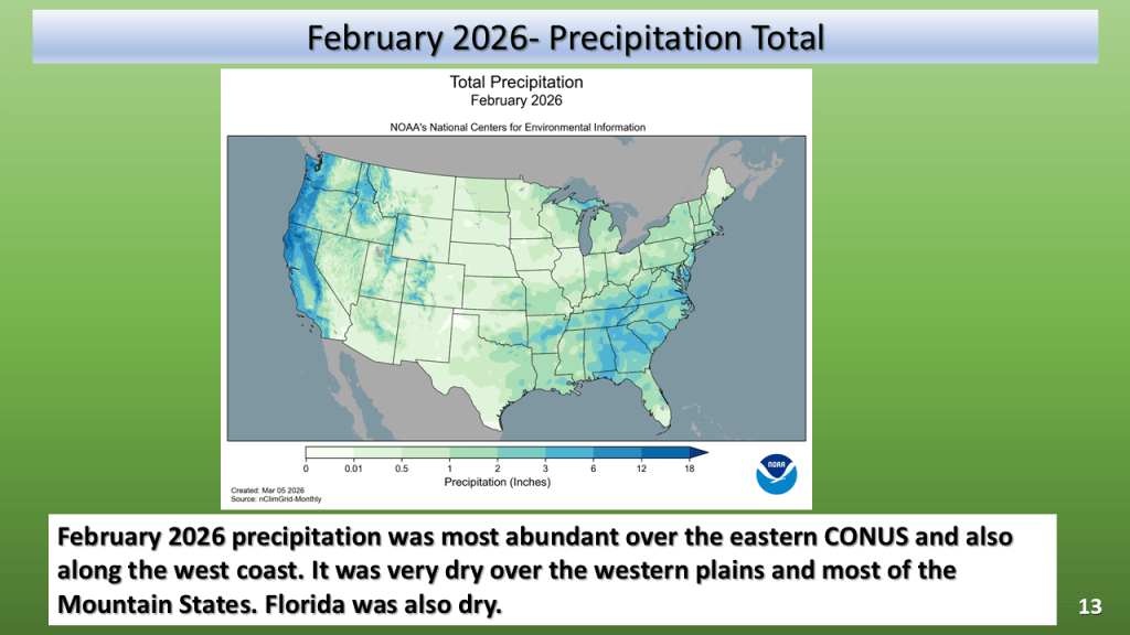
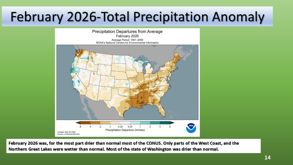
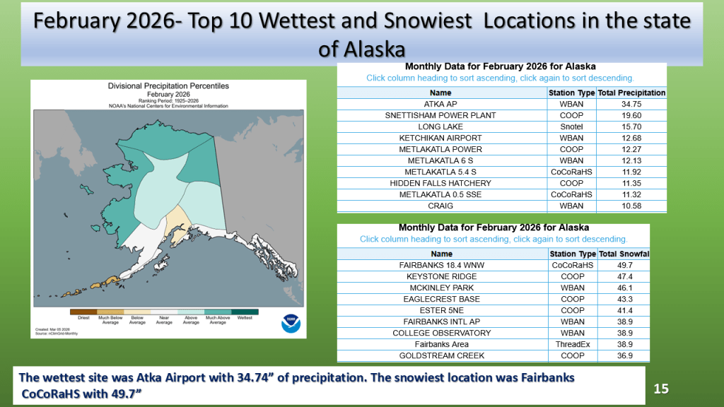
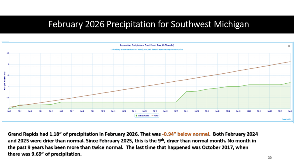
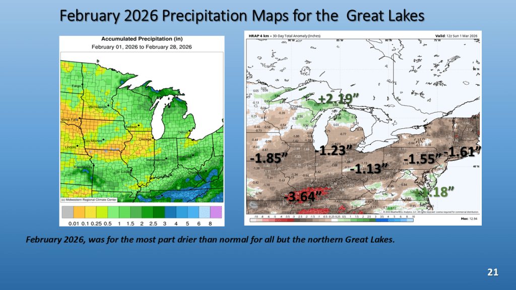
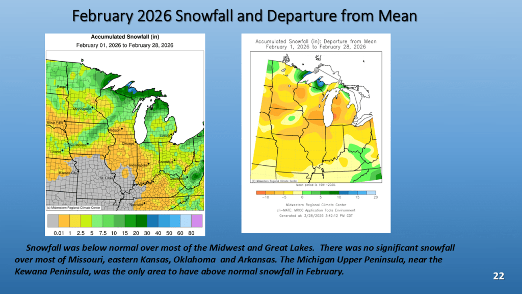
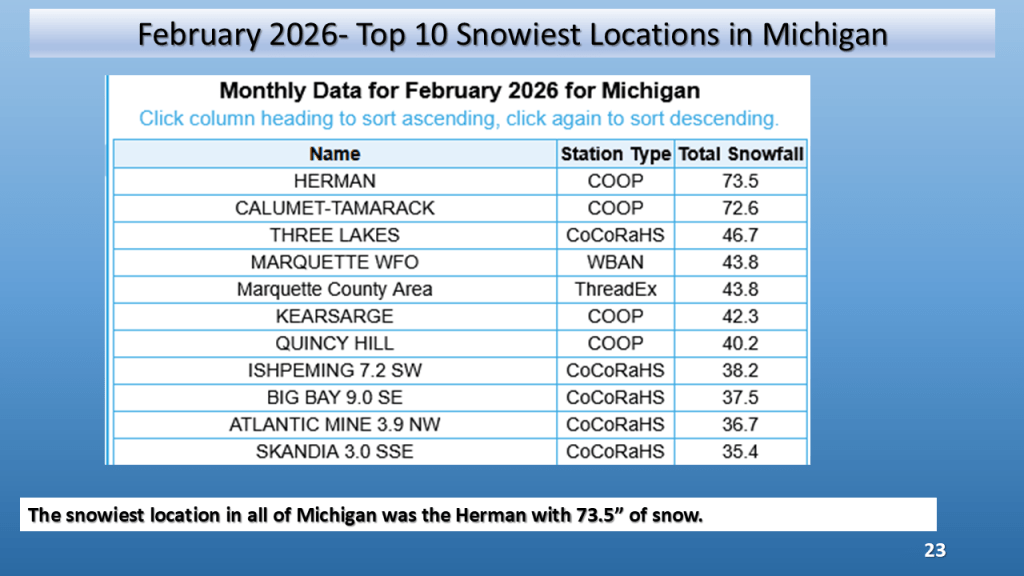
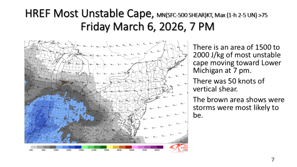
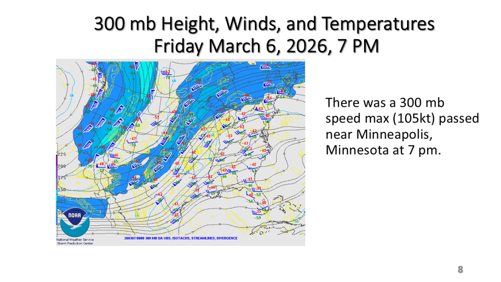
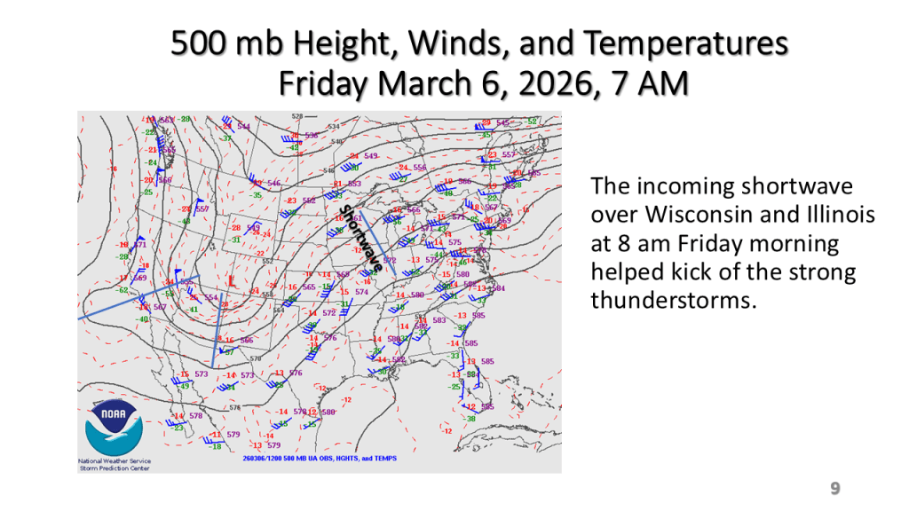
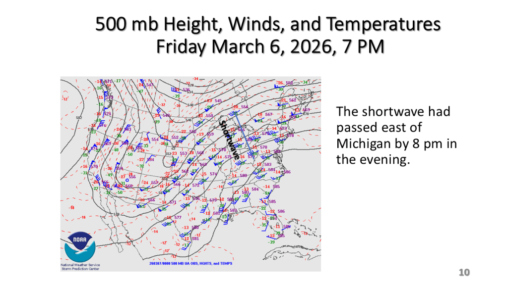
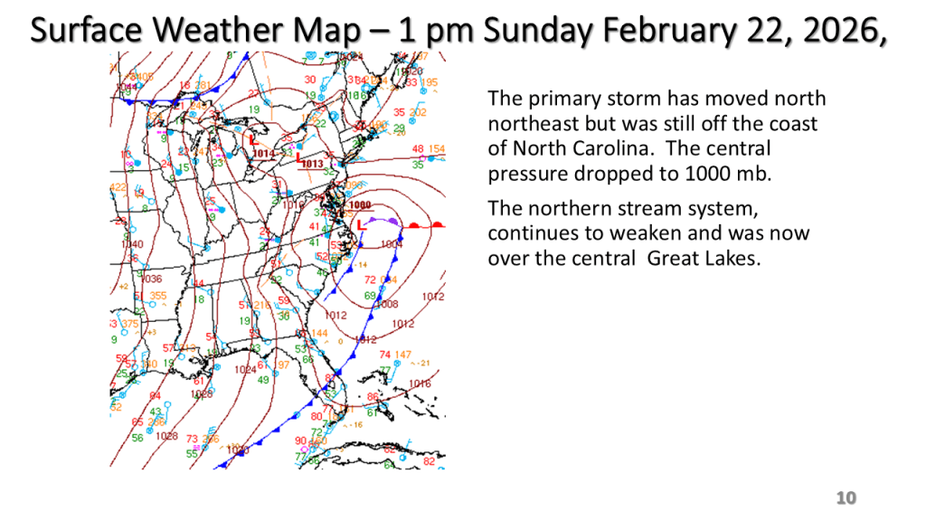
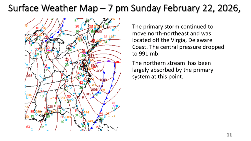
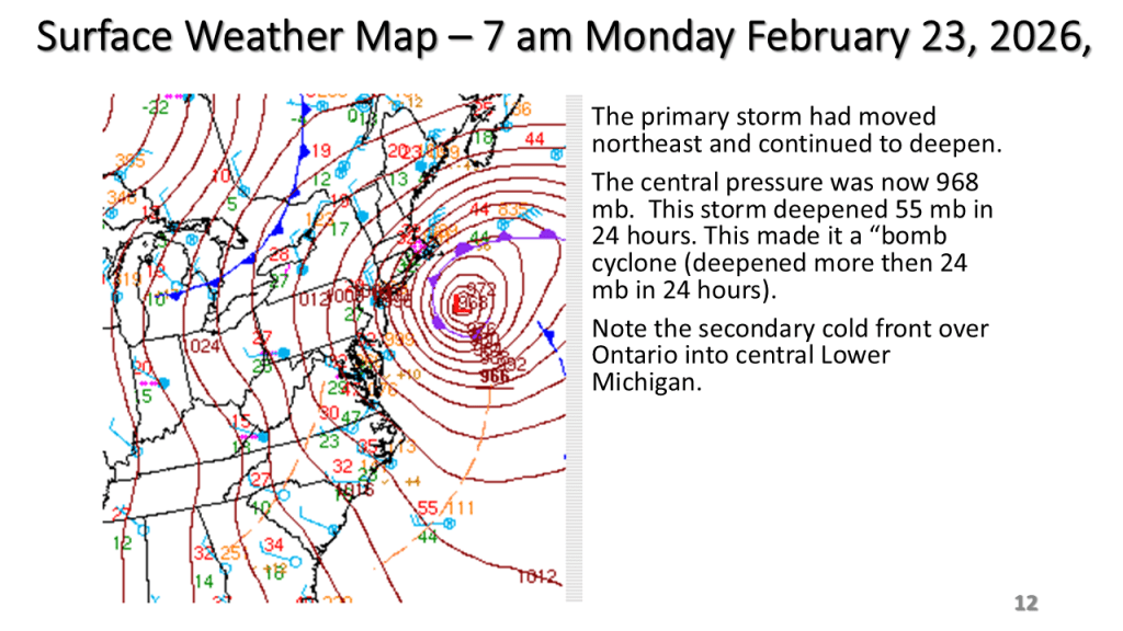
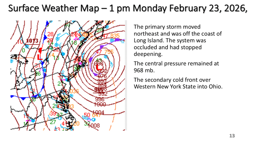
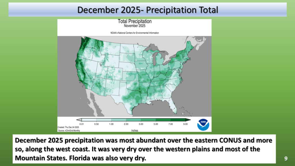
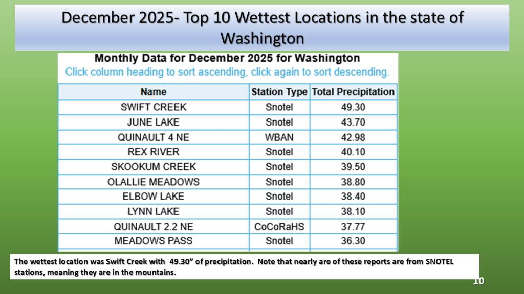
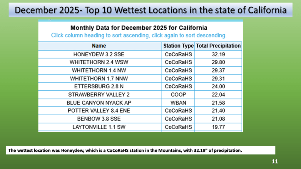
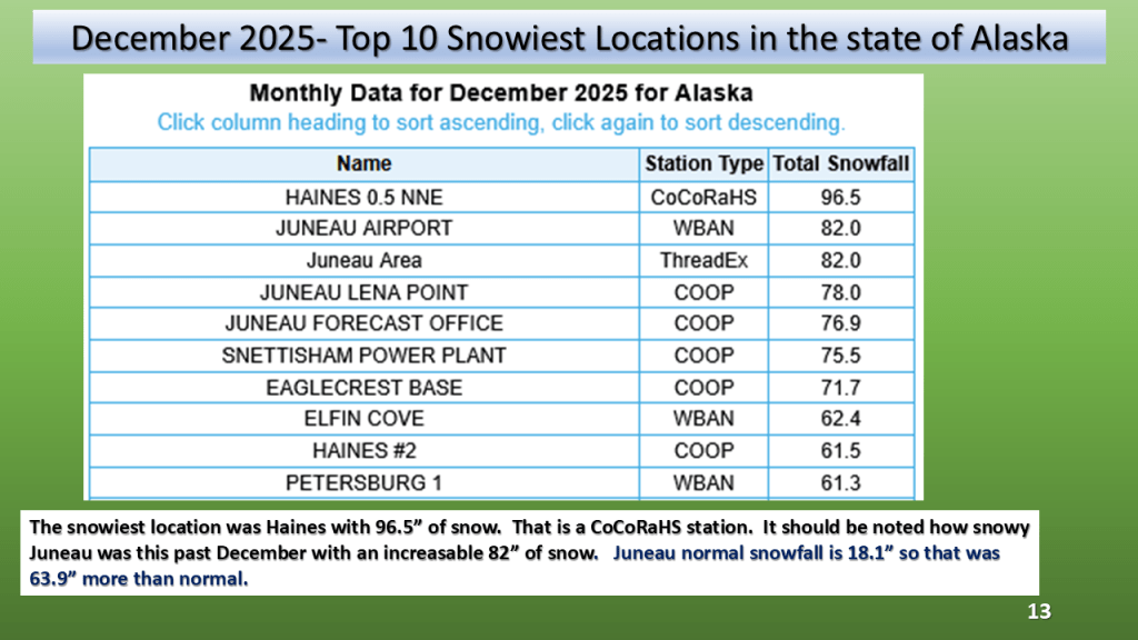
By waiting until the 8th, I can get the maps from NCEI (National Center for Environmental Information). I have added graphs from xmACIS for the daily temperature and precipitation plus I have the monthly climate summary from Grand Rapids and Gaylord.

Featured

Enjoy the warm weather this week because it will get much colder next week and parts of Michigan may even see their first snowfalls by Tuesday. Happy Halloween!

This shows our transition point from warmer to cooler weather.

Featured

The weather over the next two weeks will feature some warm and dry weather as well as cold and wet weather. Mostly it will be warm dry over the western CONUS into next week. Over the eastern CONUS it will mostly be cooler and wet. A significant warm up may follow over the eastern CONUS by the middle of next week.

Typical of fall we will see a warm up, then it will rain and get cooler, only to warm up by early next week.  Then it will get wet and cooler once again.
Featured

Expect the wet and cool weather over Northern Midwest into New England, including the Great Lakes, to persist into early next week. An impressively large blocking upper-level high, over central Canada will keep the storm track over the northern CONUS into early next week. It will also allow a subtropical system to track along the Gulf Coast over the next few days.

Featured

After having 4 days with highs in the 80s over Southwest Michigan, to start October, a series of cold fronts will lower our high temperatures by Saturday into the lower 50s. The cooler temperatures are expected to last into the middle of next week before another slow warm up begins. Widespread rainfall, mostly between a quarter and half an inch will occur Thursday as the front moves through. Lake effect rain showers are expected into early next week.

It will fell like fall by Friday morning and that chilly and showery weather my last into Tuesday morning before the system is far enough to east to allow for some clearing. It will remain chilly Tuesday into Wednesday before a warm up starts by Thursday of next week.

Featured

Some rather dramatic changes are likely in our weather over the western Great Lakes this week into early next week. Highs in the 80s are expected Sunday into Tuesday, then highs are expected to fall into lower to mid 50s by next weekend. Expect widespread rainfall during the midweek period too.

Featured

At the risk of going overboard on the Summer of 2023, I have another set of charts you may want to look at.

I through it would be fun and informative to see the frequency for hot days across our Nation.

Here I have the frequency for highs in the 90s across the CONUS (Continental United States), the longest streak across the CONUS, the frequency of lows of 70 or more and I few more NCEI charts to show how hot of a summer this was both nationally and regionally. I also have a few precipitation maps so you can see that the great frequency for hot weather was were it rained less, relative to normal for that area.

I have added 2 slides to this presentation ( 8 and 9). These two slides show that what one uses for the “normal”, greatly impacts what the departure from normal looks like. I used 1991 to 2020, the official NWS normal period for the image on the top left, then 1895 to 2000 for the image on the top right, not the area of below normal is significantly less. That is because the period 1991 to 2020 was warmer than the 1895 to 2000 period. On the bottom left the mean is 1895 to 2020, that has no below normal areas. This seems questionable to me since the ranked normal’s on the next slide look a lot like the 1895 to 2000 on slide 8. I added this because I was getting some questions on this matter. I hope this helps.

Featured

Here is my forecast for this coming week, plus a look at the current fall foliage report. The short story is warm and dry this week of the Great Lakes and northern New England. Wet along most of the East Coast and over the western CONUS. It will be cool and wet over the western CONUS.

I am expecting warm and dry weather this week over Michigan but warm and wet over the east coat, and cool and wet over the west coast.

Fall Foliage Map
Featured

Here is my updated version of the summer of 2023 climate. I have added some details on Southwest Michigan including the severe weather events this summer. I have also added slides on the large scale pattern, that is our transition from La Nina this past winter to El Nino this summer. This lead to persistent blocking over North America, which is why there were persistent heat over the south and wet weather over the eastern 1/3 of the CONUS.

This was a summer that featured persistent weather patterns over most of North America and lead to one of the most active Canadian wildfire seasons on record. It also lead the the 15th warmest summer on record (back to 1895) over the CONUS.

GRR August 24th Event Link

DTX August 24th Event Link

DTX August 24th Event Flooding Link

DTX EVENT SUMMARYhttps://www.weather.gov/dtx/severeweather07202023
DTX EVENT SUMMARY
Featured

How did the Summer of 2023 turn out weather wise across the CONUS (continental United States)? How did the summer forecast I posted in March turn out (very good for the temperature, not so great for the precipitation)

While it was the 15th warmest summer on record nationally, not all of the CONUS had a warm summer. You may want to find out how your area did relative to normal for this summer.

Featured

It appears cool weather will prevail over the eastern Continental United States (CONUS) for the next 3 weeks. It should be drier than normal over the Great Lakes but wetter than normal over the East Coast and Western Plains.

Expect the next 3 weeks to be cooler than normal over most of the eastern United States. It will be dry over the Great Lakes but very wet over the eastern seaboard.

Featured

This coming week could see our last days this year with highs on the 90s over the western Great Lakes. Little rainfall is expected until the middle of next week. Labor Day Weekend over all of Michigan and for that matter the Great Lakes.

Warmer temperatures are expected from Labor Day into the middle of the week. A cold front coming through the area in late Wednesday/Thursday time frame may bring showers and slightly cooler weather .

Featured

Here is an updated report on the storms on August 24, 2023. As it turned out there were 1 EF-1 tornado in Southwest Michigan, and EF-2 tornado in South Central Michigan and 6 tornadoes, 1 EF-0 and 5 EF-1’s in the Detriot area. I updated some of my slides for the event.

I updated my story about the severe storms since the NWS has now reported 8 tornadoes in Michigan on the 24th of August. The strongest was an EF-2 near Webbrvillle

Featured

It was a HOT JULY over most of the CONTINENTAL UNITED STATES but that was not the case for the Upper Midwest and Great Lakes.

As promised I have posted the national images of July 2023. The short story is it was the 7th warmest and 45th wettest for the CONUS. In Michigan it was the 58th warmest and 5th wettest on record.

Featured

Heavy Rain was forecast for yesterday afternoon into mid morning today. The slides below show the what actually happened.

We forecast heavy rain between I-94 and I-96 and that is exactly what did happen. The heaviest rainfall report showed 4.50 inches in Middleville, most of that area had between 1″ and 3″ of rain from the event.

Featured

Heavy Rainfall is expected over most of Lower Michigan from Monday Afternoon into Tuesday Morning

Heavy Rain is expected over most of the southern half of Lower Michigan between 2 pm Monday and 8 am Tuesday morning.

An unusually strong storm system for this time of year is expected to track east across Lower Michigan from Monday into Tuesday morning. This will be an occluded system, with the track of the surface low near I-94. It is typical for the heaviest precipitation to be within 100 miles of track of the surface low, but on the north it’s track. This system as a closed upper low with it and a coupled jet with it. The precipitable water reaches above 1.5 inches Monday afternoon over the southern 1/3 of Lower Michigan as this system tracks through the area. There is also good model continuity with this system so it gives me confidence that the heavy rainfall will happen. Just exactly were is questionable but I would have to believe between I-94 and Route 10, between Monday afternoon and Tuesday morning a large part of that area should see more than an inch of rainfall.

Featured

Cool and Wet over Lower Michigan into mid August. Warmer temperatures are expected late in the month.

Cooler than normal temperatures are expected to prevail over a large part of the northern CONUS into mid August.

We continue to see an overall eastern North American trough and western upper level ridge prevailing through the 3rd week of August. It does however look like a case of discontinuous retrogression by the later part of August as the models show a large upper ridge developing late in the month over most of the Continental United States (CONUS).

Featured

I had my all time record one hour Rainfall rate Saturday Morning, at my Grandville Weather Station.

Exceptional rainfall occurred during the early morning hours at Grandville between 1 am and 2 am. This storm broke my all time 5 minute rainfall rate record and 1 hour rainfall rate record.

With Grandville Weather Data at my house having records back to the fall of 1995, the 2.95″ of rain that was recorded in both my 4″ rain gauge and my Davis Weather Station (nice that they agreed) , is my all time record rainfall in one hour. The previous record was 2.30″ during a thunderstorm during the evening of July 17 2oo6 between 9:45 pm and 10:45 pm. The 0.50″ in 5 minutes is also a new record for 5 minute rainfall, exceeding the 0.41″ on June 18th 2021.

The pictures above are from our home, looking north out of what is my son John’s bedroom window. The time posted on the pictures are EST, so you have have to add one hour to get the correct time for these images.

Featured

Heavy Rain and Risk for Severe Storms Today

The Storm Prediction Center has put most of the southern 1/3 of Lower Michigan an enhanced risk for severe storms today (mostly late morning into mid afternoon). Locally heavy rainfall is expected too.

Most of the rainfall today will be from late morning into mid afternoon.

My experience in forecasting over the past 46 years tell me that for Southwest Michigan convection during the spring and summer months, warm fronts, stationary fronts and surface waves bring this area the most rainfall. Cold fronts bring us the least (typically). This event is warm front with a surface wave that develops into a surface low. This tells me most area should see meaningful rainfall today.

Featured

While Our Michigan Drought has Improved Considerably, Drought Looks to Continue into August

Area wide rainfall of 3 to 8 inches in July has helped reduce drought impacts but even so, the 90 day precipitation anomalies are still near 5 inches.

Featured

The second and third week of July have been cooler than normal, however, during the fourth week of July a heat wave (3 days or more in a row with highs of 90 or more) is expected for Southwest Lower Michigan. Don’t get to use to that through, cooler temperatures return by the 1st of August.

It’s been cool for the 2nd and 3rd week of July, however a dramatic change to hot weather is expected from Wednesday through Saturday.

Featured

I have updated my storm review of the 12th of July to include the information released by North Webster Indian (IWX) on the Colon EF-1 Tornado.

I added the Colon EF-1 Tornado to the storm summary plus the CoCoRaHS rainfall reports for the storm.

Featured

Yesterday We Expected Widespread Heavy Rainfall During the Late Afternoon and into Early This Morning. We also expected a slight chance of severe storms. As it turned out the rainfall forecast was very much on track as most of southern and central Lower Michigan had 2 to 4 inches of rain. There was a report of tornado near Colon Michigan at 11:06 pm. There were also several reports of wind damage, mostly south of I-96.

Heavy rain with localized flooding occurred over southern and central Lower Michigan on the evening of the 12th of July. There were also reports of damaging winds, a tornado near Colon and a few funnel cloud reports.

Featured

We are expecting heavy rain late this afternoon into early tonight across the southern half of Lower Michigan.

Heavy rain with a few thunderstorms is expected over the southern 1/3 of Lower Michigan from late afternoon until early Thursday morning. Rainfall amounts of 2″ to 4″ is expected over a large area, so that may cause some urban and small stream flooding.

The heaviest rainfall is expected between 5 pm and 9 pm this evening. Rainfall of 2 inches to 4 inches is expected with local amounts over 5 inches possible. As a result, The National Weather Service has issued a Flood Watch for the southern 1/3 of Lower Michigan until 2 am Thursday. This amount of rain will have an impact on reducing the on-going drought if in fact we actually do that that much rain over a large area.

Featured

Over the Great Lakes and Midwest, our Drought continues. There has been beneficial rainfall over some of the area, during the past week, but this has not been enough to really end the on-going drought. Above normal rainfall is expected over some of this area in the next two weeks but even that will likely not end the drought. It will however help some.

Recent rainfall has helped our drought improve some, but with rainfall anomalies being between 4 and 7 inches over the past 3 months, that has not come close to ending our current drought.

Featured

I wanted to add more depth to what I wrote yesterday. The question I want to address is how much rain do we actually need to end this drought? You may be supersized by how much rain it would take!

To end our current drought over southern Michigan we would need around 6 inches of rain by the end of July. This is near record totals for July at most of our climate sites. It would seem unlikely given our current weather pattern we would get that much widespread rainfall. So while we do expect more rain in the next month than the previous month, the expected rainfall will likely fall short of ending this drought.

Featured

After nearly 2 months of very limited rainfall, our area (Southwest Michigan) finally had around an inch of rain between the 25th and 26th of June. My blog below will look at the impact of that on our drought and the forecast going forward for the next 2 week to see if we will have a mitigation of our current drought.

Our current drought and it’s impacts continue across Michigan, this blog looks at what is happening now and then what we should expect going forward into mid July.

Featured

Rain is on the way for Sunday into Tuesday, this will help our developing drought over Lower Michigan but it likely will not be enough to end it.

It’s been unusually dry is Lower Michigan since early May, this is expected to change by Sunday.

Featured

A Very Dry May is Expected to be Followed by a Not all the Wet June over Southern Lower Michigan (at least through mid June)

May in Southwest Michigan was one of the top 10 driest on Record, the fist half of June is not expected to be all that much wetter.

Featured

You may have noticed we have an Elevated Layer of Smoke our skies over the western Great Lakes. The smoke is coming from Canada.

The smoke in the sky the past few days is coming from western and central Canada due to wildfires there.

Featured

The Latest Forecast Guidance Continues to Suggest Cooler than Normal Temperatures and Below Normal Precipitation most of the Remainder of May for the Great Lakes Area.

Over Southwest Michigan, May has largely been drier than normal and cooler than normal Overall the next two weeks will mostly be that way.

Featured

Cool and Wet into Tuesday, than mostly dry weather and becoming warmer than normal by the weekend and that is expected to continue into the 3rd week in May.

It may be cool today and tomorrow but warmer than normal temperatures are expected from this coming weekend through the 3rd week in May.

Featured

What is the risk of freeze over the next week or so? Put another way, when will it be safe (this spring) to start planting freeze sensitive plants over the Great Lakes and Ohio Valley?

Freezing low temperatures should be expected over Lower Michigan next week (first week of May)

Featured

More On The Summer Forecast for Southwest Michigan, this time looking at both monthly anomalies and the frequency of highs in the 90s

I am expecting this summer, in Southwest Michigan to be near normal to slightly warmer than normal in the mean temperature but the frequency of very hot days, highs of 90F or more is likely to be less than normal.

Featured

After nearly 4 months of mostly warmer than normal temperatures an extended period of cooler weather is forecast for Southwest Michigan.

Cooler temperatures are expected to prevail over southwest Michigan into through the first week of May. Milder conditions are expected to follow by mid month.

Why May This Change Be Happening?

As for why this may be happening I will look at the how the water temperatures in the Tropical Pacific have recently changed. Typically this sort of change forces large scale changes in the northern hemisphere wave pattern.

Featured

Updated Summer Forecast For Southwest Michigan

I am expecting the summer of 2023, over southwest west Michigan to feature near normal temperatures when June, July and August’s mean temperatures are averaged together. I am also expecting this summer to be wetter than normal across all of Southwest Michigan

I have updated my summer forecast for southwest Michigan based on the impact of warmer sea surface temperature over most of oceans in the more recent 30 years. Curiously the outcome, from my updated analogs would suggest a near normal temperature outcome and but a continued wet weather pattern into the summer months.