It may be late March but we can still get meaningful snow in Southwest Michigan through the month of April!
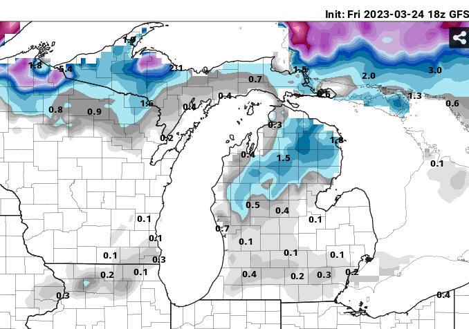
While we may well get a significant (shovel-able) amount of snow and enough ice accumulation in areas near or just north of I-96 Saturday, as typical of late March storms, most of the snow and ice will likely be gone by Sunday afternoon. Below is the model (GFS) forecast snow depth by Sunday evening at 8pm.
I want to point out what the typical March high has been since 1991 at Grand Rapids. There has been a slight negative trend from 69f to 68F in the past 30 years. The median maximum temperature for March is 69F . Having a maximum March temperature below 60 is unusual as you can see from the chart above. There have been 6 years out of 30 (20%) when this has happened.
This will be short version of this idea, I will post something with more detail next week (CPC issues a new forecast on Thursday) and I want to look at more information. Still what I know now is worth sharing.
The last forecast from CPC (Feb 16th) suggests a warm summer is slightly higher odds than does a near normal or cool summer but the odds are not great, 35% for warm, 33% for near normal and 32% for colder than normal.
However, if we look at all years when there was a La Nina during the winter (there was this winter) when the winter in Southwest Michigan was warmer than normal, like it was this past winter, we see from the charts below the spring it typically warmer than normal with near normal precipitation.
As for the summer we see the warmer than normal trend continues and precipitation remains near normal south of I-96 but it’s wet north of I-96
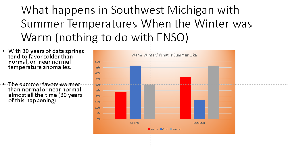
Since southwest Michigan had a warm winter, let’s look at what happens when the winter is warm, not caring about the state of ENSO.
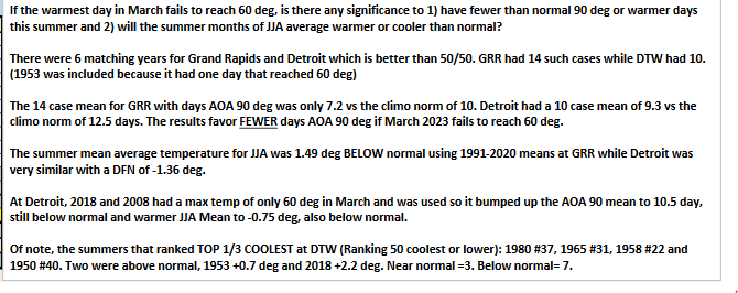
Now here is something that may change that story! So far, most of southern Lower Michigan has not had a daily the temperature above 60F. The extended ensembles of both the GFS and ECMWF, while not ruling out one or two days with highs that warm, odds are very low at this point. Neither model means show highs that warm, it is only 1 or 2 out of 50 of the ECMWF that are forecasting highs that warm by the end of March. So below is a joint study by Gary Rizzo and myself on what happens at both Grand Rapids and Detriot.
So, this will be fun to watch how this plays out! We already know that if at Grand Rapids the daily high reaches 90F in May there will be a much higher than normal number of 90F days but it now seems we have a filter for below normal numbers of highs in the 90s.
Once again next week I will put info out on our coming summer, but I through it’d be fun to post this this week.
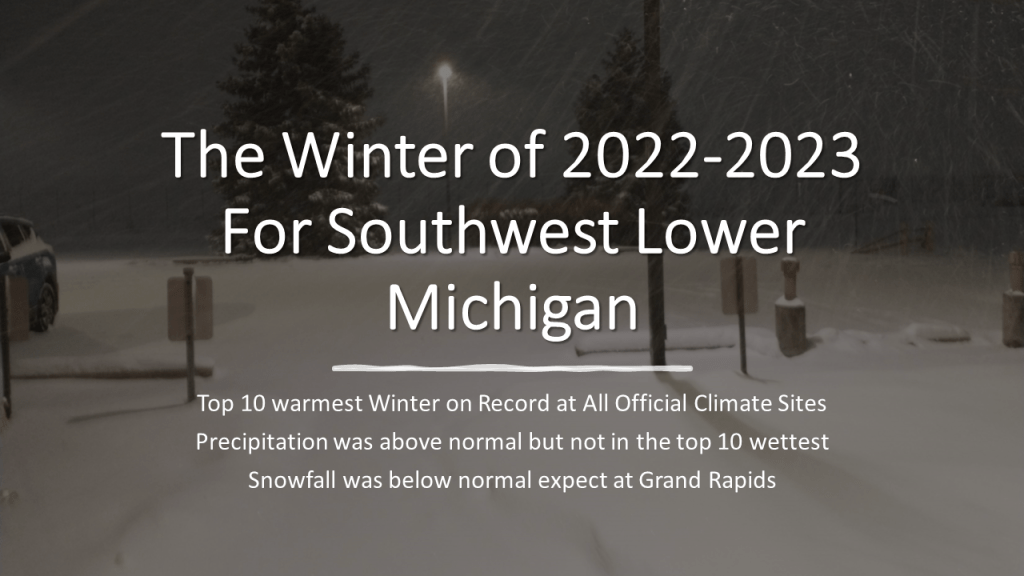
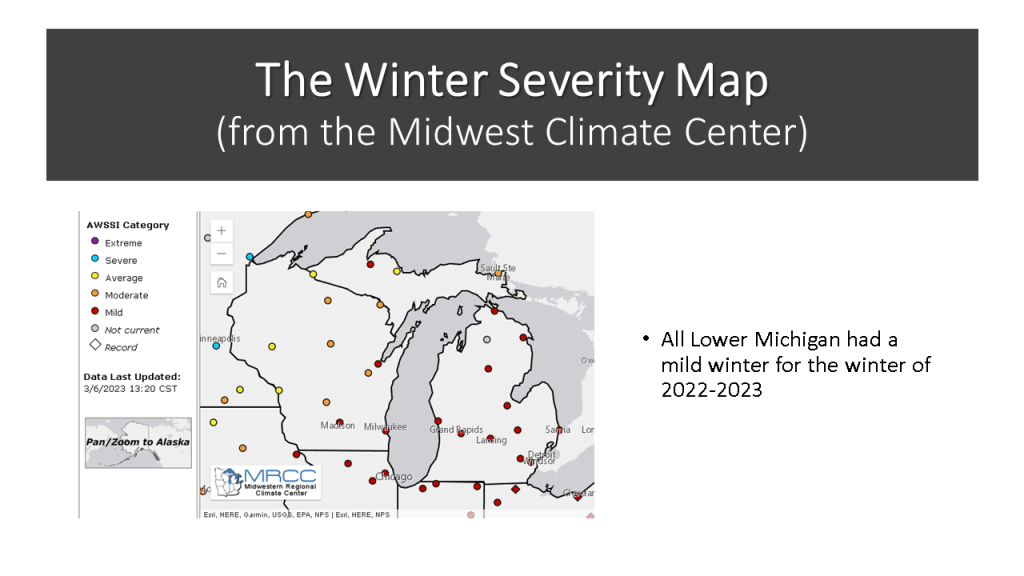
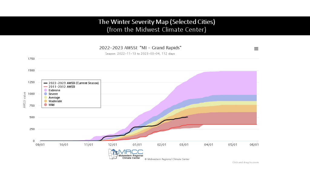
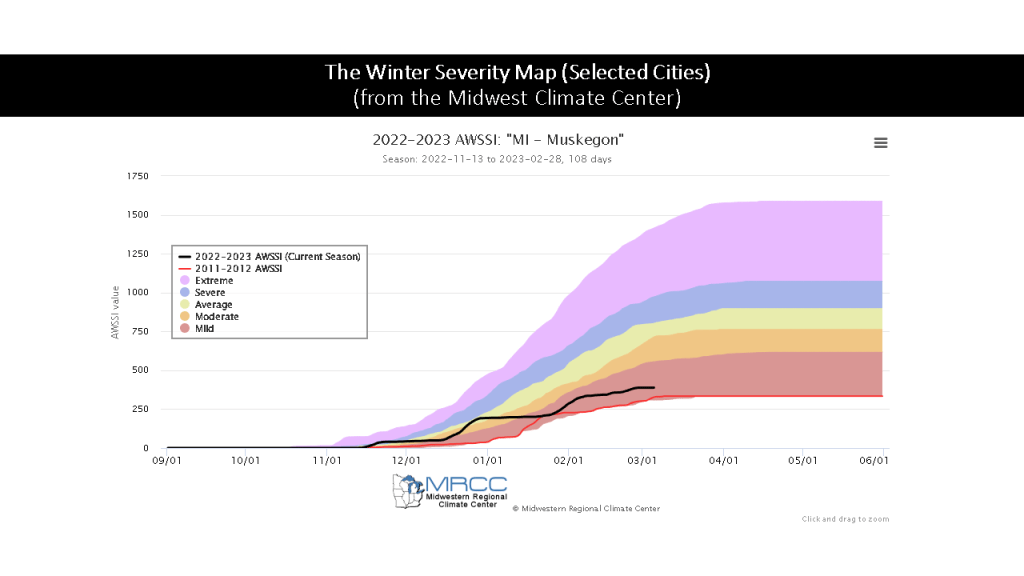
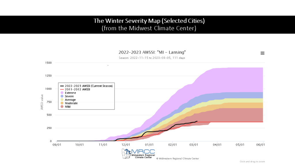
The Winter of 2022-2023 was the 4th warmer than normal winter in the past 10 years, only 2 winters in the past 10 have been colder than normal 2013/2014 and 2014/2015. The other 4 winters were near normal.
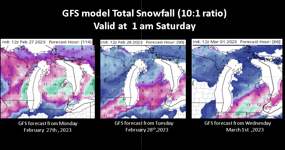
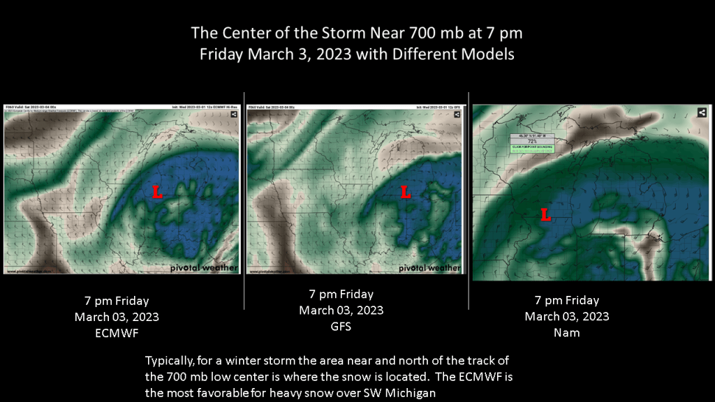
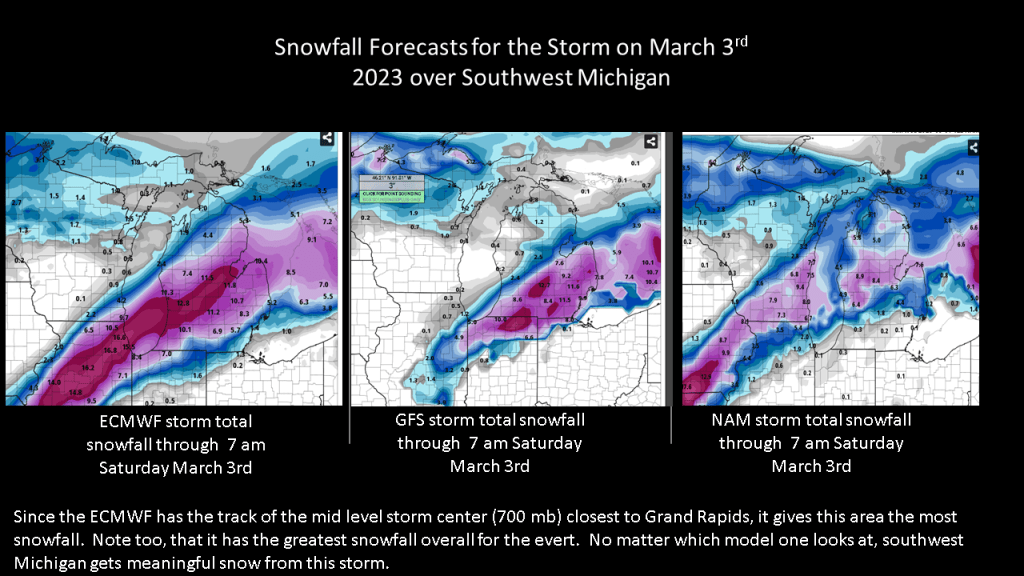
I will agree with a tweet by the Grand Rapids National Weather Service yesterday afternoon, that forecasting exactly where the heaviest snow will end up today has not been all that easy. Still there has been a clear shift to the southeast over time with the forecast heavy snow amounts.
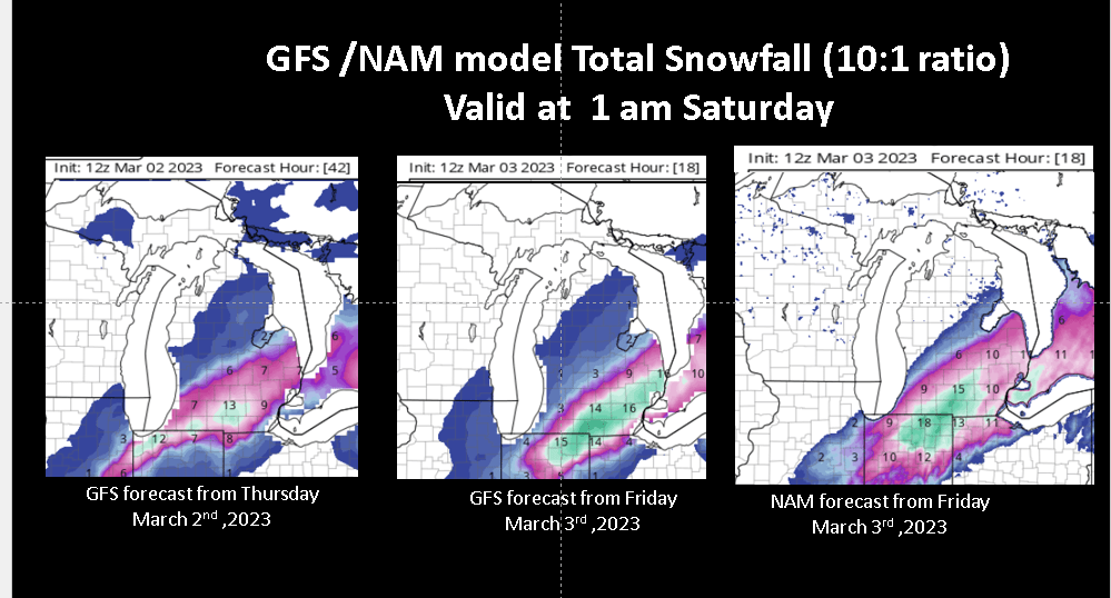
Below shows the GFS forecast model (from Tropical Tidbits) total snowfall forecast from the 12z (7 am EST ) model run for the past 5 days. On the second slide, I have the NAM forecast for today also.
Note the clear shift in the axis of the heaviest snowfall from Monday through today. Monday the GFS had the heaviest snow near I-96, by Wednesday the heaviest snowfall shifted so south of line from Saginaw to Holland. On this morning’s runs of the GFS and NAM, and for that matter the HRRR numerous hours in a row, plus the HREF, all have the heavy snow south of Grand Rapids to near Lansing to near Saginaw.
One other point about this, just about every run has an area with over a foot of snow. This storm has great upper level and mid level support plus Gulf Moisture to help it’s cause. So, there will be an area of heavy wet snow with this storm, but likely it will stay south of a line from Saginaw to Grand Rapids.
Actually once you get north of a line from Muskegon to Houghton Lake, there may not be any snow at all from this storm!
With temperatures near freezing, it will be a heavy wet snow. With at storm center being below 978 mb currently ( 2 pm), this storm will feature a fair amount of wind this evening but it is questionable given how wet the snow will be if it will blow around much. Still travel over Michigan, south of Grand Rapids will be challenging by mid evening. The snowfall should end around midnight.
I am thinking were I live in Grandville may only see an inch or two from this storm. We shall see tomorrow morning!
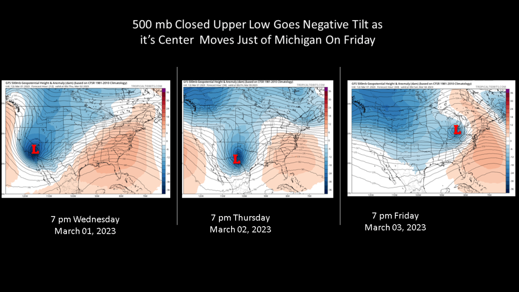
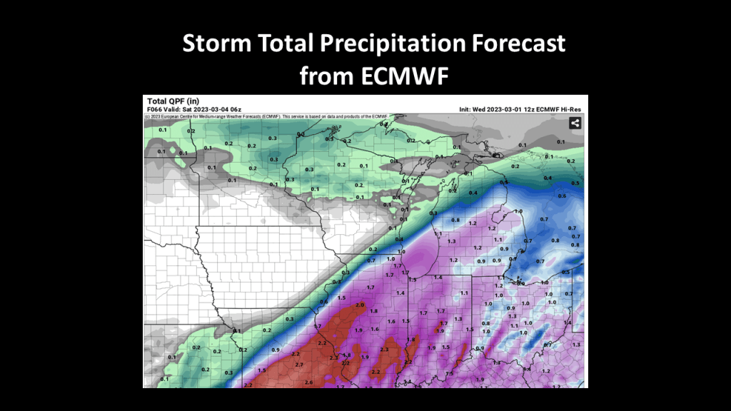
I have put together a few slides to show there is significant change our area could see an impactful winter weather event Friday into early Saturday. The storm has been consistently forecast to impact our area for several days now on the ECMWF, GFS, and the ensemble members of both of those models.
This is one of those storms with strong upper level forcing and a good feed of moisture from the Gulf of Mexico. Since the upper level part of the storm is closed off and upper wave goes negative tilt as the storm moves through our area, that significantly increases the risk of a major winter weather event on Friday.
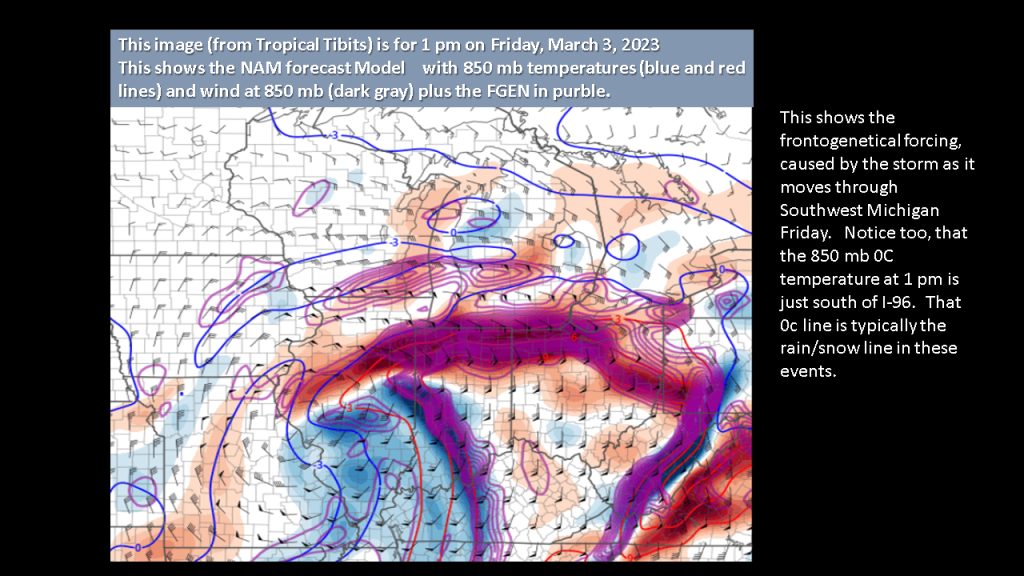
This storm will not only have an area of heavy snowfall but it will have strong winds to blow the snow around.
Below the a few slides to help make my point that this will be an impactful storm for most of Southwest Michigan.
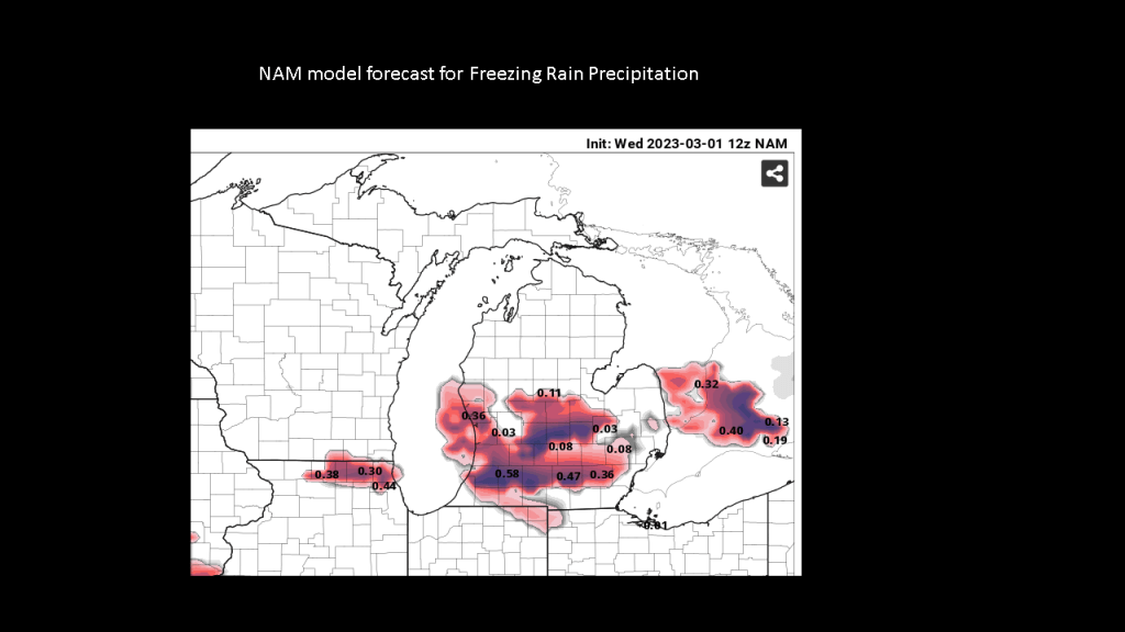
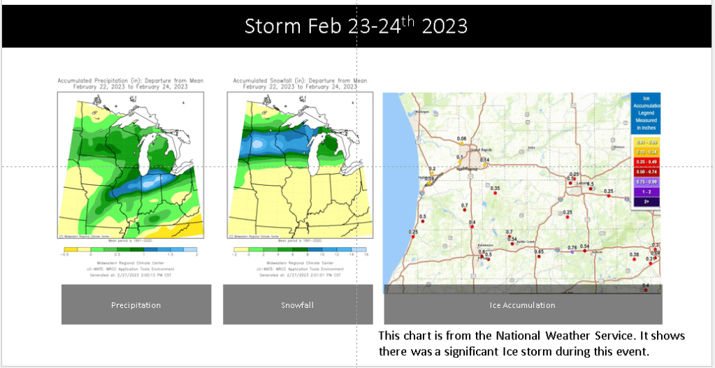
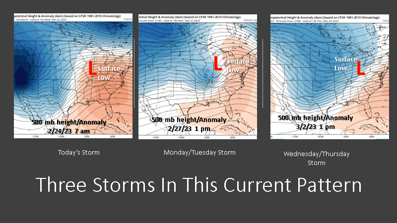
Last Wednesday, February 22, 2023 I suggest there would be three significant storm between the 23rd of February and the end of this this current week. As it turns out, 5 days later the story as not changed at all. Clearly we got the storm on the 23th. That was a major ice storm from Kalamazoo to Jackson and as far north as Lansing. Below are the precipitation totals for that storm, snowfall totals and the ice accumulations.
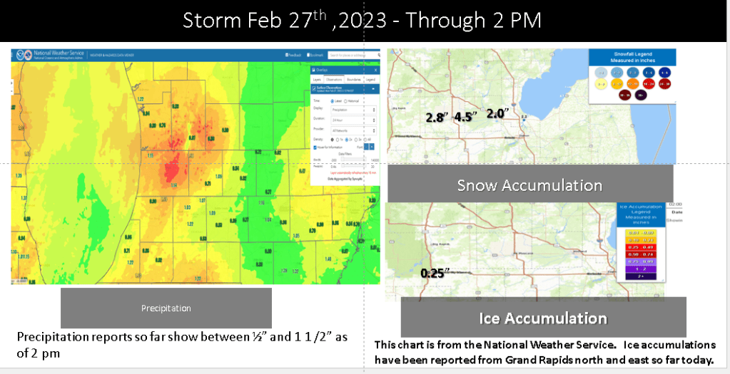
Today we are currently getting the second storm I suggested would happen on the 27th. This has brought between a half inch and one and one half inches of precipitation to large area of Southwest Michigan. The has been 2 to 5 inches of snow from Mount Pleasant northward too.
Below are the maps for precipitation, snowfall and ice accumulation for today, as of 2 pm.
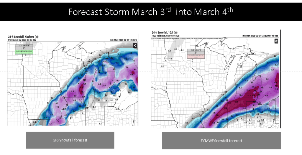
As for the storm I suggested would occur late this week, that still looks to be on track too.
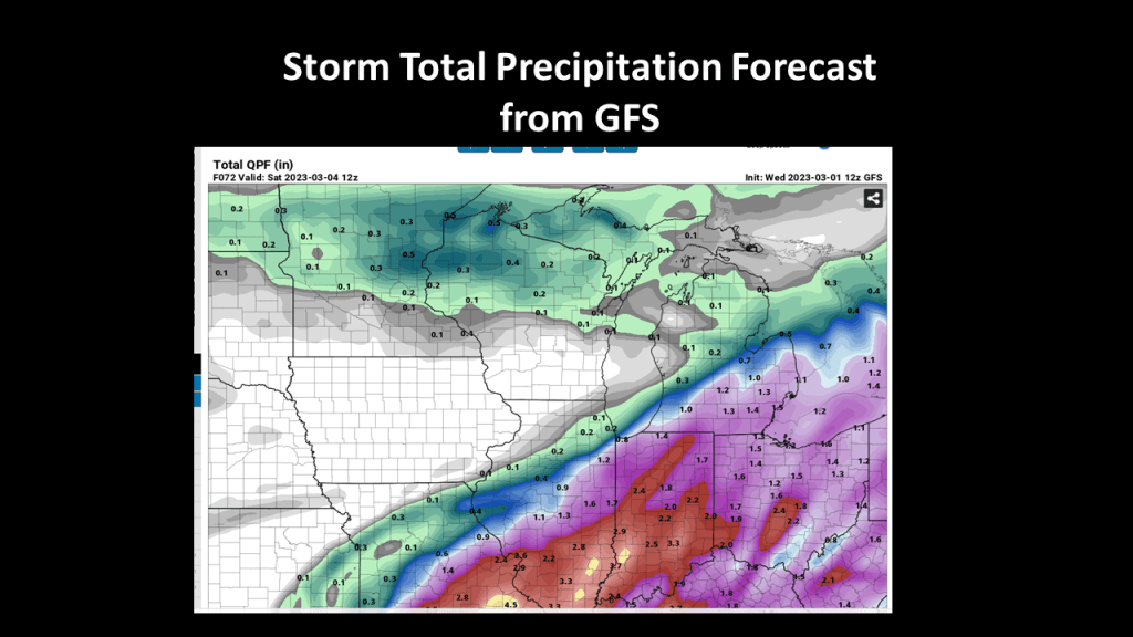
The (thanks to Pivotal Weather) chart below shows the 24 hour total snow forecast from both the GFS (left) and ECMWF (right) between Friday at 7 am and Saturday and 7 am. It should be noted that the GFS has been very consistent with the track and snowfall over the past 5 days, while the ECMWF has had this storm tracking to our south. Only that last 24 hours has the ECMWF has the snow reaching our area.
The thing for us to watch with this storm is, will the models keep tracking it farther north over time? If so this too may be just another rain, sleet and ice event for us. Nonetheless this storm as the potion to bring significant impact to Southwest Michigan.
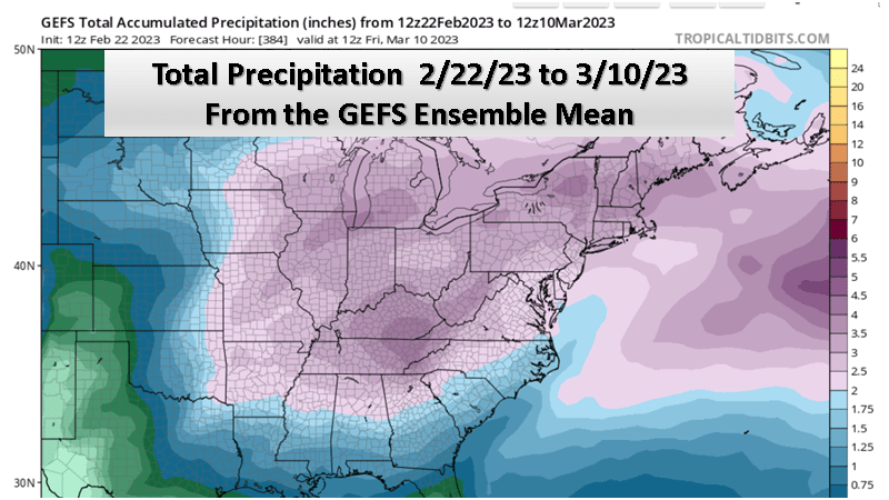
The map below (from Tropical Tidbits) shows the total ensemble mean precipitation expected over the next 2 weeks. Note the expected precipitation is in the 3 to 4 inch range over all of Michigan with the heaviest amounts over Southwest Michigan. It should be noted that while I am showing the GEFS forecast the ECMWF looks very similar for this time period.
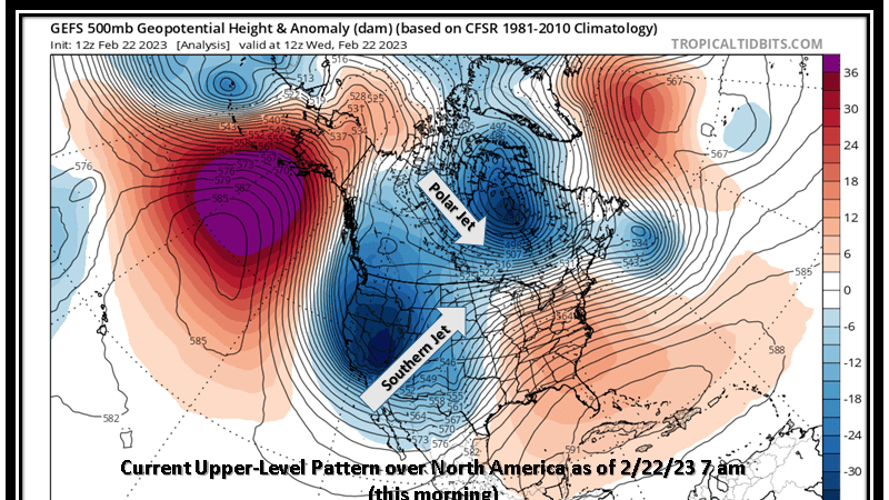
We currently have an upper air pattern that features a western United States upper trough and eastern United States upper ridge. The map below shows this very nicely. This shows a large storm system at upper levels over the western United States and large upper high over the Gulf and eastern Atlantic south of Florida. You may note too the polar jet, which is where the cold air is locked, is over central Canada. It is the southern stream jet that is bringing the moisture for our storm today.
The problem for us is that that deep western trough does not get kicked out with today’s storm. That means we will see more systems come out of this through. As you can see on the side below, the system that comes out today does not really flatten the upper ridge to our east. However the deep system over the western United States does finally start to move east, but in parts. The first part comes out early next week, with a negative tilt upper wave. That storm could be as wet or even wetter than what we have today. Then if that is not enough, yet a third system seems likely when the western upper trough finally moves out late next week.
The bottom line is expect a stormy end to February and a storm beginning to March.